
Last eruption June 1957 | Elevation 180 m | |
 | ||
Similar Metis Shoal, Kao, Nabukelevu, Zealandia Bank, Tofua | ||
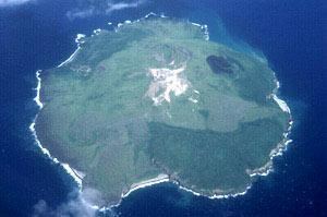
Fonualei is an uninhabited 5 km2 volcanic island close to Vavaʻu in the kingdom of Tonga. It was seen by Don Francisco Mourelle de la Rua on the La Princesa on 26 February 1781. He reported the island to be barren from eruptions, and called it for that reason Amargura (Bitterness in Spanish).
Map of Fonualei, Tonga
A major eruption in 1846, starting 11 June, destroyed much of the vegetation of Vavaʻu and spread ash around for at least a year. Some sources claim that three other neighbouring volcanoes, Late, Tokū and another, erupted at the same time. This is probably a mistake by passing ships who misidentified the erupting island.
The closest island to Fonualei is Tokū 19.7 km to the southeast.
References
Fonualei Wikipedia(Text) CC BY-SA