
 | ||
Similar Saddle Hill, Mount Cargill, Andersons Bay, Rock and Pillar Range, Trotters Gorge | ||
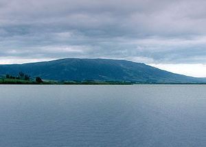
Often incorrectly called The Maungatuas or The Maungatua Range, Maungatua is a prominent ridge which dominates the skyline of the Taieri Plains in Otago, New Zealand. Rising 900 metres above the floodplain of the Taieri River, directly to the west of Dunedin's airport at Momona, it can be clearly seen from much of Dunedin's urban area, 35 kilometres to the east, and from as far south as the outskirts of Balclutha, 65 kilometres to the southwest. Lake Mahinerangi is located on the western side of Maungatua.
Contents
Map of Maungatua, Woodside 9073, New Zealand
The name Maungatua comes from the Maori words Maunga-atua, meaning "Hill of the spirits".
Ecology of MaungatuaEdit
On the summit of Maungatua there are swamps that contain species of insect eating plants called sundews. At the base of Maungatua glowworms may be found living in manuka trees.