
Country United States County Plymouth Incorporated 1640 Elevation 5.18 m Population 25,132 (2010) | State Massachusetts Settled 1632 Time zone Eastern (UTC-5) Zip code 02050 Local time Monday 2:51 PM | |
 | ||
Weather -2°C, Wind NE at 11 km/h, 35% Humidity | ||
Video of 20 eastward lane marshfield massachusetts real estate homes by dietmar stapelfeld
Marshfield is a town in Plymouth County, Massachusetts, United States, on Massachusetts's South Shore. The population was 25,132 at the 2010 census.
Contents
- Video of 20 eastward lane marshfield massachusetts real estate homes by dietmar stapelfeld
- Map of Marshfield MA USA
- Video of 955 duck hill llane marshfield massachusetts real estate homes
- Geography
- Demographics
- Government
- Education
- Transportation
- Notable people
- References
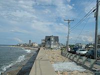
Map of Marshfield, MA, USA
See also: Green Harbor, Marshfield (CDP), Marshfield Hills, and Ocean Bluff-Brant Rock.
Video of 955 duck hill llane marshfield massachusetts real estate homes
Geography
Marshfield is located on the South Shore, about where Cape Cod Bay meets Massachusetts Bay.
According to the United States Census Bureau, the town has a total area of 31.74 square miles (82.2 km²). 28.46 square miles (73.7 km²) of it is land and 3.28 square miles (8.5 km²) of it (10.33%) is water. Marshfield is bordered by Massachusetts Bay to the east, Duxbury to the south and southeast, Pembroke to the west, Norwell to the northwest, and Scituate to the north and northeast. Marshfield is 18 miles (29 km) east of Brockton and 29 miles (47 km) southeast of Boston.
Marshfield is named for the many salt marshes which border the salt and brackish borders of the town. There are three rivers, the North (along the northern border of the town), South (which branches at the mouth of the North River and heads south through the town) and the Green Harbor River (which flows just west of Brant Rock and Green Harbor Point at the south of town).
The South River divides a peninsula from the rest of the town, where Rexhame village and the Humarock and Fourth Cliff neighborhoods of the town of Scituate lie. The Scituate neighborhoods can be reached by land by two bridges, by boat, or by foot along Rexhame Beach. The Rexhame-Humarock peninsula is a barrier beach with an 84-foot-high (26 m) moraine, one of only two barrier beach moraines on the east coast of the United States.
Marshfield is the site of several small forests and conservation areas, including the Daniel Webster Wildlife Sanctuary along the Green Harbor River and the North River Wildlife Sanctuary along Route 3A.
The town of Marshfield has six separate zip codes: Marshfield (02050), Brant Rock (02020), Ocean Bluff (02065), North Marshfield (02059), Marshfield Hills (02051), and Green Harbor (02041). There are eight villages in the town: Marshfield Center, Fieldston, Ocean Bluff, Rexhame, Brant Rock, Green Harbor, Marshfield Hills, and North Marshfield.
The following beaches comprise Marshfield's 5-mile-long (8 km) public seashore: Rexhame, Fieldston, Sunrise, Ocean Bluff, Brant Rock, Blackman's Point, Blue Fish Cove, Burke's and Green Harbor. Marshfield is a popular summer beach destination. Tourists and vacationers cause the town's population to nearly double from Memorial Day through Labor Day weekend. Only full-time residents can vote on public tax matters.
Demographics
As of the census of 2000, there were 24,324 people, 8,905 households, and 6,598 families residing in the town. The population density was 854.8 people per square mile (330.1/km²). There were 9,954 housing units at an average density of 349.8 per square mile (135.1/km²). The racial makeup of the town was 92.69% White, 3.54% Black or African American, 0.11% Native American, 0.37% Asian, 0.02% Pacific Islander, 0.52% from other races, and 0.76% from two or more races. Hispanic or Latino of any race were 2.67% of the population.
There were 8,905 households out of which 37.4% had children under the age of 18 living with them, 60.9% were married couples living together, 10.1% had a female householder with no husband present, and 25.9% were non-families. 20.9% of all households were made up of individuals and 7.2% had someone living alone who was 65 years of age or older. The average household size was 2.73 and the average family size was 3.20.
In the town, the population was spread out with 27.4% under the age of 18, 5.7% from 18 to 24, 31.2% from 25 to 44, 26.2% from 45 to 64, and 9.5% who were 65 years of age or older. The median age was 37 years. For every 100 females there were 95.3 males. For every 100 females age 18 and over, there were 91.6 males.
The median income for a household in the town was $142,610. and the median income for a family was $172,330. The median home value was $890,000. Males had a median income of $111,992 versus $83,773 for females. The per capita income for the town was $92,012. About 0.6% of families and 0.2% of the population were below the poverty line, including 6.7% of those under age 18 and 4.8% of those age 65 or over.
Government
On the national level, Marshfield is a part of Massachusetts's 9th congressional district, and is currently represented by William Keating (D). The state's senior (Class I) senator, elected in 2012, is Elizabeth Warren. The junior (Class II) senator, elected in 2013, is Ed Markey.
On the state level, Marshfield is represented in the Massachusetts House of Representatives as a part of the Fourth Plymouth district, which also includes much of the town of Scituate. The representative for Marshfield and Scituate in the Massachusetts House of Representatives is Jim Cantwell (D). The town is represented by Robert Hedlund (R) in the Massachusetts Senate as a part of the Plymouth and Norfolk district, which includes the towns of Cohasset, Duxbury, Hingham, Hull, Norwell, Scituate and Weymouth. The town is patrolled by the First (Norwell) Barracks of Troop D of the Massachusetts State Police.
Marshfield is governed on the local level by the open town meeting form of government, and is led by a town administrator and a board of selectmen. The current board of selectmen includes a direct descendant of Pilgrim Richard Warren. The modern town hall is located at the intersection of Routes 3A and 139, just south of the South River. The town has its own police and fire stations, with firehouses located in Marshfield Hills, Ocean Bluff and near the fairgrounds. The town's Ventress Memorial Library is located a short distance east of the town hall, and is a member of the Old Colony Library Network (OCLN). There is also an independent library, the Clift Rodgers Free Library, in Marshfield Hills. The town has three post offices, in the same neighborhoods as the fire stations.
Education
Marshfield operates its own school system for the town's nearly 4,700 students. There are five elementary schools:
The Elementary Schools serve students from pre-kindergarten through fifth grade. (Eames Way and South River, however, do not have pre-kindergarten classes).
The Furnace Brook Middle School serves students from sixth through eighth grade. FBMS is a top school, winner of the Jimmy Fund Cancer Research Foundation Contest in 2006, 2007,2009, 2011, 2013 and 2014. The school consists of 3 clusters in each grade level (Red, Yellow, and Crimson in 6th; Green, Purple, and Blue in 7th; and Gold, Pink, and Orange in 8th).
Marshfield High School serves grades nine through twelve. Marshfield High School's athletic teams are known as the Rams, and their colors are green, white, and black. Their chief rival is Duxbury High School and they play against them in the Thanksgiving football game. There are no private or vocational schools in the town; the nearest private schools are in neighboring Scituate and Duxbury (as well as a charter school in Norwell). The nearest college is Bridgewater State College in the town of Bridgewater.
Transportation
Massachusetts Route 3, also known as the Pilgrims Highway, skirts the town along the Pembroke town line, and can be accessed in Marshfield via the Route 139 exit. Route 139 loops through the town, with a long portion passing along the beaches of the Ocean Bluff and Fieldston neighborhoods before heading north and east into Pembroke. Route 3A also passes through the town, entering from the south in Duxbury and exiting over the North River into Scituate.
There is daily bus service connecting with the MBTA station in Braintree and another bus connecting with South Station in Boston. The nearest train station is the Greenbush station in Scituate. There is a commuter ferry to Boston available in Hingham. The nearest major airport is Logan International Airport in Boston. The area is also served by T.F. Green Airport in Rhode Island and the town's own municipal airport for general aviation. The nearest freight rail service is in Wareham.