
Type Tornado outbreak Tornadoes confirmed 64 confirmed Duration of tornado outbreak 2 days, 5 hours Damage 543.4 million USD | Duration March 11–13, 1990 Max rating Start date March 11, 1990 Number of casualties 2 | |
 | ||
Similar 1990 Plainfield tornado, May 2007 tornado outbreak, Tornado outbreak of April 26, Windsor Locks - Connecti, May 18–21 - 2013 torn | ||
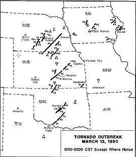
The March 1990 Central United States tornado outbreak affected portions of the United States Great Plains and Midwest regions from Iowa to Texas from March 11 to March 13, 1990. The outbreak produced at least 64 tornadoes across the region, including four violent tornadoes; two tornadoes, which touched down north and west of Wichita, Kansas, were both rated F5, including the tornado that struck Hesston. In Nebraska, several strong tornadoes touched down across the southern and central portion of the state, including an F4 that traveled for 131 miles (211 km). Two people were killed in the outbreak, one apiece by the two F5s in Kansas.
Contents
Overview
The Central United States tornado outbreak of March 13, 1990, was one of the most violent outbreaks ever documented in March (second only to the Palm Sunday tornado outbreak of 1920 in terms of violent tornadoes and the March 2006 Tornado Outbreak Sequence in terms of the total number of tornadoes reported). Numerous tornadoes touched down across Nebraska, Kansas, Oklahoma, and Iowa. Two tornadic thunderstorms with exceptional life spans/tornado families were observed, one of which produced an F4 tornado in eastern Nebraska that was on the ground for over 100 miles (160 km). The other produced an extensive tornado family in southern Kansas that included two F5 tornadoes. The first of these struck the town of Hesston, Kansas, and was one of the most photographed and documented violent tornadoes in history.
Confirmed tornadoes
(based on NOAA Storm Data)
The Hesston and Goessel tornado family
The tornadoes that struck Hesston and Goessel were both spawned by the same supercell thunderstorm. They were part of what is known as a tornado family; a family that included several additional touchdowns after the Goessel storm dissipated.
The first tornado of the Hesston storm touched down at approximately 4:34 p.m. CDT just to the northeast of Pretty Prairie. It was initially between 200 and 500 yards in diameter, and caused minimal (F1-F2) damage as it churned between Castleton and the Cheney Reservoir. Photographic evidence suggests significant widening as the tornado approached Haven and the Arkansas River. The damage path ranged between 1/2 and 3/4 miles near Haven, and several homes were completely demolished indicating F4 damage. Had the tornado moved through a more populated area in this stage of its life, it is likely that it would have caused much more dramatic damage. Fairly constant F3 damage was produced from Haven to Burrton and to the Little Arkansas River. The path width remained over 0.5 miles (0.80 km) in diameter.
Northeast of the Little Arkansas, the track abruptly decreased in width from 0.5 miles (0.80 km) to just over 300 yards (270 m). Photographs suggest what appears to be a re-organization of the tornadic circulation; initially a wedge like appearance, the funnel quickly became tall and narrow. The most significant damage was done in this stage, however. The tornado plowed into the town of Hesston, just northwest of Newton on I-135. A total of 226 homes and 21 businesses were destroyed, and several were swept completely from their foundations with only slabs and empty basements remaining. Several industrial buildings were obliterated, and vehicles were thrown and stripped down to their frames. Portions of the damage path in Hesston were rated F5. 20 farms were torn apart in rural areas outside of town. Light debris from Hesston was found 115 miles (185 km) away in Nebraska. One person died and 59 people were injured.
The series of events that occurred as the tornado moved past the Hesston area were most interesting. Eyewitness accounts observed the touchdown of an additional tornado just to the north. This is consistent with models of what is known as a "tornado handoff", in which an old mesocyclone and tornado occlude as a new mesocyclone and tornado further downwind becomes dominant. Over the course of a few miles, the new tornado intensified and the original one abruptly constricted and apparently became a satellite tornado to the new tornado. Eventually, the Hesston tornado (after traveling nearly 48 miles (77 km)) occluded and merged with the new tornado, and the supercell began to re-intensify. The new tornado rapidly became very large, and violent damage was produced by the second tornado in Marion County. Several homes were again completely obliterated and swept away and one additional fatality was reported. The tornado produced very severe cycloidal ground scouring in farm fields, and damage near the town of Goessel was "extreme F5" according to NWS damage surveyors. The severity of the damage left behind by this tornado led some meteorologists to believe that the Goessel tornado was among the strongest ever documented at that time. The storm passed Goessel and then dissipated approximately 22 miles (35 km) from its genesis.