
- location Lake Kajarabie Basin area 20,039 km² Source Consuelo Tableland | - elevation 574 m (1,883 ft) - elevation 207 m (679 ft) Basin area 20,039 km² | |
 | ||
- location | ||
Mitchell flood maranoa river thurs 2nd feb 2012
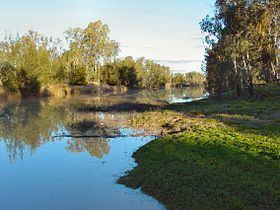
The Maranoa River, part of the Murray-Darling basin, is a river situated in South West Queensland, Australia.
Contents
- Mitchell flood maranoa river thurs 2nd feb 2012
- Mitchell weir on the maranoa river queensland overflowing 2nd march 2010 avi
- Course and features
- Popular culture
- References
Mitchell weir on the maranoa river queensland overflowing 2nd march 2010 avi
Course and features
Formed by the confluence of the west and east branches of the river, the Maranoa River rises on the Consuelo Tableland in the Carnarvon National Park. The valleys in the river's catchment area are broad rather than gorge-like as in the nearby Carnarvon Gorge, with isolated bluffs and pillars of sandstone on sandy plains. The Maranoa passes through Mitchell and flows south towards St George. The river reaches its confluence with the Balonne River north of St George. The Balonne eventually flows into the Darling River (via a few branches), so it contributes to the Murray-Darling Basin. From source to mouth, the Maranoa is joined by 31 tributaries including the Merivale River and descends 366 metres (1,201 ft) over its 519-kilometre (322 mi) course.
The Warrego Highway crosses the river at Mitchell.
The Neil Turner Weir was built on the river in 1984. It provides limited supplies for irrigation purposes as well supplying drinking water for the town of Mitchell. It also regulates streamflow and has recreational uses.
Major flooding on the river occurred in 1990.
Popular culture
A number of Australian folksongs (such as Sandy Maranoa and The Maranoa Drovers) refer to this river.