Population 2,647 (2011 census) Postcode(s) 4487 Postal code 4487 Number of airports 1 | Established 1862 Elevation 201 m Local time Friday 12:20 PM | |
 | ||
Location 513 km (319 mi) from Brisbane389 km (242 mi) from Toowoomba194 km (121 mi) from Roma162 km (101 mi) from Hebel Weather 23°C, Wind SW at 21 km/h, 42% Humidity | ||
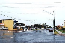
St George is a town and locality in the Shire of Balonne, Queensland, Australia. It is the administrative centre for the Shire of Balonne. In the 2011 census, St George had a population of 2,647 people.
Contents
- Map of St George QLD 4487 Australia
- Geography
- History
- Floods
- Heritage listings
- Industry
- Notable residents
- Facilities
- Education
- Local events
- References
Map of St George QLD 4487, Australia
Geography
The town is 513 kilometres (319 mi) due west of Brisbane and the Gold Coast and sits just inside the region of South West Queensland, Australia.
St George is on the Balonne River which is reputedly an excellent fishing site for fish such as Yellowbelly and Murray Cod.
It sits at the junction of several highways including the Castlereagh Highway, the Moonie Highway, the Carnarvon Highway and the Balonne Highway. The only crossing of the Balonne River is the Andrew Nixon Bridge on the Balonne Highway.
History
The town was named by Major Thomas Mitchell who crossed the Balonne River on St George's Day, 23 April 1846.
At the 2011 census, St George had a population of 2,647.
Floods
The town was severely affected by flooding in March 2010, which peaked at 13.5 metres, and again in December 2010 - January 2011.
Flooding once again occurred in February 2012. When there was a possibility of the river reaching 15 metres, about 2000 residents were mandatorily evacuated on 4 and 5 February to evacuation centres in Dalby and Brisbane. A temporary levee was built in St George on the morning of 5 February (Sunday). The Balonne River reached a height of 13.85 metres on Tuesday 7 February.
Heritage listings
St George has the following heritage-listed sites:
Industry
The town is a centre for cotton growing, as well as sheep and wheat.
Notable residents
St George gained national attention with the election of local accountant Barnaby Joyce to the Australian Senate following the 2004 federal election. It is also the hometown of National Rugby League player Dale Shearer.
Facilities
St George has a public library, visitor information centre, cultural centre, swimming pool, showground, bowling and the St George Golf Club.The address of the golf club is Wagoo Road. It was opened in 1948. The town also has an airport, St George Airport.
Education
St George State School is a government co-educational primary (P-6) school at 20-40 Grey Street. The school opened on 2 February 1874. In 2015, the school had an enrolment of 217 students with 24 teachers (22 full-time equivalent) and 15 non-teaching staff (12 full-time equivalent).
St George State High School is a government co-educational secondary (7-12) school at 2 Victoria Street. The school opened on 23 January 1978. In 2015, the school had an enrolment of 221 students with 25 teachers (22 full-time equivalent) and 24 non-teaching staff (17 full-time equivalent).
Local events
The St George show is celebrated every year over the Labour Day long weekend (weekend of the first Monday in May), Everyone is encouraged to go and locals have a great time sharing stories at the bar and watching the rodeo.
