
Established 1960 Area code 015 | Elevation 167.9 m (550.9 ft) | |
 | ||
Weather 19°C, Wind S at 6 km/h, 86% Humidity | ||
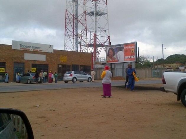
Malamulele town
Malamulele can refer to the town of Malamulele or the area of Malamulele. Both the town (approximately in the center of the area) and area are in the Limpopo province of South Africa and predominantly occupied by Tsonga people. Malamulele is flanked by two rivers, Levubu River (Rivhubye) to the west and Letaba River to the east, meanwhile the Shingwedzi River runs from Malamulele West to Malamulele East, joining the Limpopo River in Mozambique on its way to the Indian Ocean. Malamulele is the seat of the Collins Chabane Local Municipality.
Contents
- Malamulele town
- Anger on the streets of malamulele
- Etymology
- Languages
- History
- Geography and climate
- Political atmosphere
- Demographics
- Residential Areas
- Bevhula
- Madonsi
- Magona
- Mhinga
- Mukhomi
- Xikundu Shikundu
- Mulamula
- Mavambe
- Xigalo
- References
There are between 100 and 120 villages in the Malamulele area, with an approximate population of half a million. According to official Stats SA census 2011 results, some 82 Malamulele villages (excluding the township), were home to 206,646 people. In 2001, Thulamela calculated the population according to some 16 main areas (again, excluding the township), supposedly representing the number of independent chiefs, which add up to 199,807 inhabitants.
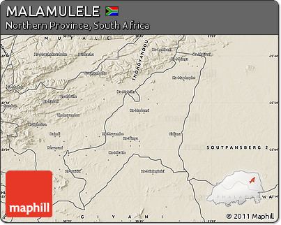
The Malamulele Area is situated between Giyani on the east, starting at Letaba river, and Thohoyandou on the north-west, starting at Rivhubye river. To the west of Malamulele Area is Waterval, famous for the Elim Hospital. The Malamulele Area is in the process of obtaining its own independent municipality separate from Thulamela but still under the Vhembe District Municipality.
To the north-east of Malamulele Town is the Kruger National Park, where it is located 63 km away from the Punda Maria gate, 72 km from the Punda Maria Rest Camp, 99 km from the Shingwedzi Rest Camp, 108 km from the Pafuri Rest Camp and 135 km from the Mopani Rest Camp. Malamulele Town is 243 km away from Polokwane (the capital of Limpopo Province), 453 km away from Pretoria and 508 km from Johannesburg.
The shortest straight-line distance from Malamulele Town to the Zimbabwe border is about 60 km, 60 km to the Mozambique border and almost 300 km to the Swaziland border. Its proximity to Zimbabwe and Mozambique makes Malamulele one of the northern-most towns in South Africa.
Anger on the streets of malamulele
Etymology
The name Malamulele comes from the word "lamulela", which itself comes from lamula. To lamula means to stop a fight or to save. "Lamulela" then means to save someone or help someone. Malamulele is the noun for the person who saves or helps, a saviour. Sometimes Malamulele is written as "Malamulela", but this is an unpopular form of the name which does not follow Xitsonga grammatical rules.
Nationally it is common to refer to Malamulele as eka Malamulele or ka Malamulele. These references both mean to say in Malamulele or at Malamulele. It is wrong to say eMalamulele or e-Malamulele. In Afrikaans, Malamulele can be referred to as in Malamulele.
Languages
The Luleke sub-dialect of the N'walungu dialect of the Tsonga language is spoken in the Mhinga, Makuleke and Ntlhaveni areas. For example, i mani? (who is it?) becomes hi mani?. The rest of Malamulele speaks pretty much standard Xitsonga, except the Dzonga ndzi becomes ni.
Spelling have been standardised to reflect standard Tsonga, i.e. "sh" and "tsh" are "x", while "vh" and "v" have been corrected from the Tshivenda corruption introduced by Thulamela Municipality. "B" has also changed to "v" where appropriate. Examples: Mabiligwe would be Maviligwe, Mudabula would be Mudavula, Tshikundu would be Xikundu, Shikundu would be Xikundu, Shigamani would be Xigamani, Nyavhani would be Nyavani, Ka-Vhele would be Nkavele. All prefixes (ka-) have been removed because they are assumed. At times "e-" and "eka" were used as prefixes. These as well have been removed because they add no value to the article as it is not written in Xitsonga.
History
Malamulele was borne out of the homeland settlement system imposed by the Apartheid government. The people of Malamulele come from both sides of the Rivhubye and were resettled on the eastern side. Most of the people in Phaphazela village come from Malonga in what is now Vuwani. Phaphazela used to be called Malonga in remembrance of their former lands. Some people of the Makhuvele lineage were removed from parts of what is now Thohoyandou. Thus some of the people of Malamulele are the Magwamba, who used to form the Xipilongo (Spelonken) Empire. There has also been communities that were moved from what is now the Kruger National Park to settle in Malamulele. About 40,000 people were moved from west of Rivhubye and settled in Malamulele, whereas about 10,000 were moved from Malamulele and settled in what was to become Venda.
Malamulele was the first town to be built in the former Gazankulu homeland, prior to Giyani. It was named by Chief Risimati Chanyela Mulamula. It was one of the former 7 districts of Gazankulu, namely Nkowa-Nkowa, N'wa-Mitwa, Lulekani, Mhala, Hlanganani, Giyani, and of course, Malamulele. At the end of apartheid, Malamulele was renamed to Levubu-Shingwedzi Transitional Local Municipality, after the two rivers. A amalgamation with Thohoyandou led to what is called the Thulamela Local Municipality, which then centralised all administration and services in Thohoyandou.
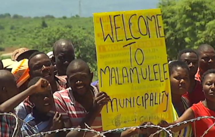
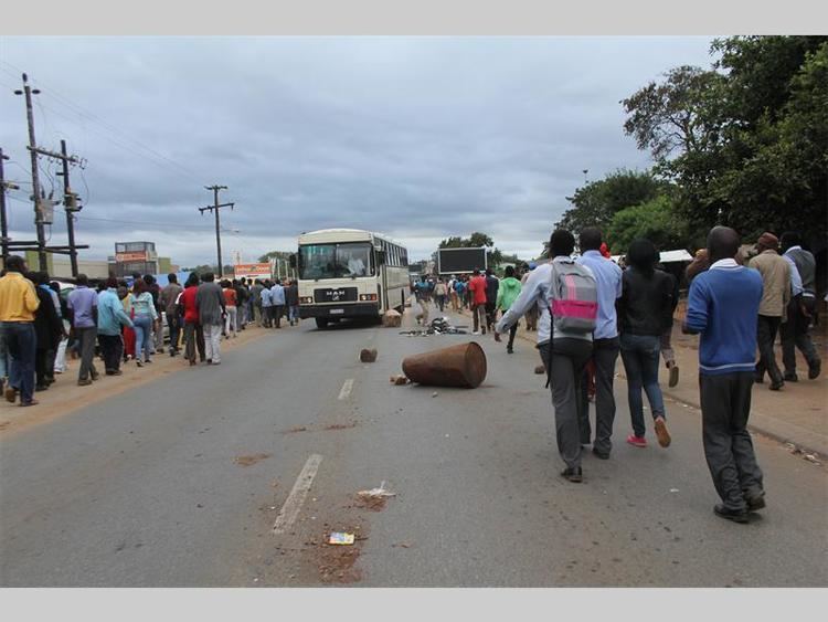
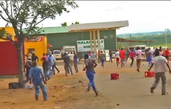
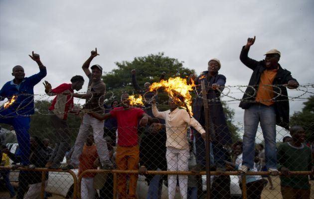
The years 2000 to 2015 saw consistent objections to the merger with Thohoyandou. In the last few years, the objections went from peaceful applications to the Municipal Demarcation Board to violent protests with property being damaged. The protests were mired with accusations of tribalism and a reductionism tactic to say all South African municipalities face service delivery protests. The issue was demonstrated to be imbalanced services between Thohoyandou areas and Malamulele areas. Even with poor service delivery, Thohoyandou areas still enjoyed better service in comparison to Malamulele areas. In July 2015, the Municipal Demarcation Board announced that a new municipality would be formed to serve Malamulele.
Geography and climate
Malamulele is a low-lying area at risk of flooding. There are a lot of hills, but no known mountains. The soil structure is mainly sandy grey soil (ntlhava), that's why the area called Ntlhaveni. Malamulele is approximately 1551.93 km² in land area. It has a perimeter of 178.283 km². The area is sparsely populated with a lot of bush between neighbouring settlements. The town has a very dry subtropical climate, specifically a humid subtropical climate (Köppen climate classification: Cwa), with long hot and rainy summers and short cool and dry winters.
Political atmosphere
Since 1994, the first time that the people of Malamulele and the rest of black South Africa were ever allowed to vote, the electorate has always voted for the ANC. A few voted for Ximoko xa Rixaka (Whip of the Nation), which has now morphed into XPP (Ximoko Progressive Party). Since then, the majority of Malamulele has voted the ANC by default, with around 80% of the votes going to the ANC, about 20% higher than the national average.
Demographics
The Malamulele area encompasses approximately 100 to 120 villages, with a total population nearing 500,000. According to the 2011 Stats SA census, 82 villages within Malamulele (not including the township) had a population of 206,646. Concurrently, Malamulele Town itself recorded a population of 13,070. A decade earlier, in 2001, the Thulamela municipality had segmented the population into around 16 main areas (excluding the township), thought to correspond to the jurisdictions of independent chiefs, tallying up to a total of 199,807 individuals. During this same period, Malamulele Town had a population of 11,299. These main areas are: Gijana (Magona), Madonsi, Makuleke, Mavambe, Mhinga, Mphambo, Mtititi, Mudavula, Mukhomi, Mulamula, Mulenzhe, Ntlhaveni (Bevhula), Tshikonelo, Xigalo, Xigamane, and Xikundu, thereby recognising 14 Tsonga and 2 Venda (Mulenzhe and Tshikonelo) chiefs. These places account for 1362.01 km² of Malamulele's 1551.93 km² total land area.
For perspective, its north western neighbour, Thohoyandou, had a population of 69,453 in 2011, more than double its 2001 population of 32,730. Its eastern neighbour, Giyani, rose from 22,725 to 25,954.
Residential Areas
Malamulele Town is surrounded by a number of areas belonging to tihosi (chiefs). Each chief has a number of villages under his ownership. Each of his matiko (villages), except for the one he resides at, has a ndhuna (headman). There may be disputes as to whether one is a chief or a headman, as well as whether a section is a new village or just a section of an existing village. As a result of population growth, almost all of these villages have expanded, creating what is called miganga (sections). These sections are so big, they may sometimes be referred to as villages. In addition to the villages, there are two informal settlements on the fringes of the town, namely Rhulani and Xipurapura. There is also one other smaller business district, Saselamani. It has a shopping complex and a police station.
There used to be one tertiary institution, Shingwedzi College of Education, but it has since been dissolved by the ANC government. There are about 45 high schools, 5 of which are in town. The 5 in town are: E.P.P. Mhinga High School (Section B), Mahlahle Combined School (Section C), Malamulele High School (Section A), New Era College (Section A), Okani Commercial College. Mahlahle and New Era are private schools, while the others are public or government schools. On average, there are two primary schools per high school, amounting to between 90 and 100 primary schools. There is on average one pre-school at every village.
In terms of chieftaincies and disputes therein, a headman usually only heads one village, but as villages grow bigger, this may not be a perfect metric. Where such disputes occur, the chief being disputed comes within braces next to the verified chief. These disputes are historical from Apartheid times, when the Gazankulu homeland was divided into districts. Some headmen tend to claim to be chiefs, while some chiefs have been robbed of their chieftaincies.
Bevhula
Madonsi
Magona
Mhinga
The clan name of the Mtititi ruling family is Chauke. they are of the Vahlengwe lineage. The sub-villages include Altein, Muhunguti, Plange and Lombard
The clan name of the Mtititi ruling family is Chauke. they are of the Vahlengwe lineage. The sub-villages include Altein, Muhunguti, Plange and Lombard