
Basin area 4,826 km² Basin area 4,826 km² | - elevation 203 m (666 ft) Length 200 km | |
 | ||
- right Dzindi RiverMutshindudi RiverMutale River - location Limpopo River, South Africa-Mozambique border | ||
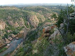
The Levubu River or Levuvhu (Tsonga: Rivubye; Venda: Luvuvhu) is located in the northern Limpopo province of South Africa. Some of its tributaries, such as the Mutshindudi River and Mutale River rise in the Soutpansberg Mountains.
Contents
Map of Luvuvhu River, South Africa
The Luvuvhu River flows for about 200 km through a diverse range of landscapes before it joins the Limpopo River in the Fever Tree Forest area, near Pafuri in the Kruger National Park.
A Zambezi shark (Carcharhinus leucas) was caught at the confluence of the Limpopo and Luvuvhu Rivers in July 1950. Zambezi sharks tolerate fresh water and can travel far up rivers like the Limpopo.
Dams
References
Levubu River Wikipedia(Text) CC BY-SA