
Length 20.91 km | Counties: Hancock | |
 | ||
Existed: 1925, 2007 (current alignment) – present North end: SR 3 / SR 198 in Bar Harbor | ||
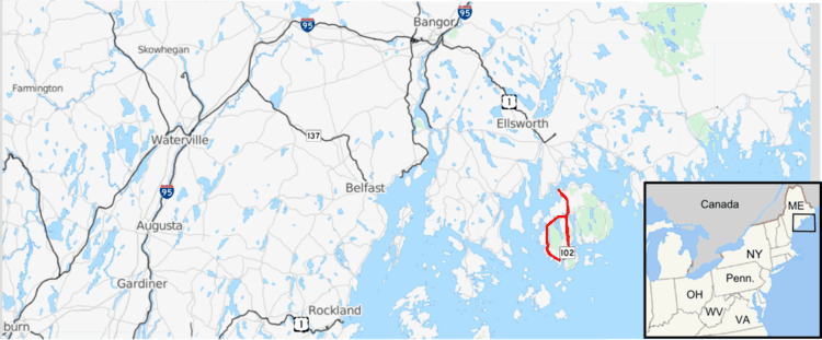
State Route 102 is a north-south state highway located on Mount Desert Island in eastern Maine. As of 2007, its southern terminus is located at an intersection with State Route 102A in Tremont on the southern part of the island. Its northern terminus is at intersection with State Route 3 in Bar Harbor, a terminus it shares with State Route 198.
Contents
Map of ME-102, Maine, USA
Route description
SR 102 begins in the south at the intersection of Harbor Drive and Tremont Road in Tremont. SR 102A also has its "northern" terminus at this intersection; it is a 3/4 loop serving Bass Harbor to the south. SR 102 runs due north, entering Southwest Harbor and intersecting the other end of SR 102A south of the town center. Continuing north, SR 102 enters the town of Mount Desert and intersects SR 3/SR 198 near the Mount Desert Campground. SR 3 has its eastern terminus at this intersection, but is generally not assigned cardinal directions as it loops the eastern half Mount Desert Island in order to avoid confusion. SR 198 is a "dead-end" coastal route serving Northeast Harbor, located opposite Somes Sound from Southwest Harbor. SR 233, the most direct route to downtown Bar Harbor, is located nearby. Heading north, SR 102 is cosigned with SR 198 as the two routes enter the northwestern corner of Bar Harbor. Just before reaching Thompson Island in on the Trenton town line, the highway meets up with SR 3 once again. SR 102 and SR 198 both terminate at this intersection, with SR 3 continuing north (signed west) onto the Maine mainland.
History
SR 102 was originally designated in 1925 and ran between Augusta and Belfast. It has also maintained most of its routing through Mount Desert, but most of the old route was later superseded by the designation of SR 3. SR 102 was overlapped with SR 3 in Trenton and Ellsworth until 1946, when it was truncated to run between Seal Cove and its current northern terminus at SR 3 in Bar Harbor.
In 1951, the southern portion of the route was extended, causing SR 102 to loop around the island clockwise along Tremont Road and Pretty Marsh Road and terminate at itself near Somes Pond, creating a lasso-shaped route in which one could be traveling due north on a road signed "south". SR 102 signage was removed from the western half of the loop in 2007, truncating SR 102 to the terminus of SR 102A in Tremont, leaving the rest of the loop unnumbered and referred to by the name Pretty Marsh Road. It was also removed from the official Acadia National Park map to match, though older Park signage at some intersections does still refer to Rt. 102 on this unsigned portion.
Junction list
The entire route is in Hancock County.
State Route 102A
State Route 102A is a loop of SR 102 on the southeastern tip of Mount Desert Island. It connects to SR 102 in Tremont and Southwest Harbor, passing through the Manset and Seawall areas along the way and running for 6.84 miles (11.01 km).
It forms a nearly complete loop and, for the most part, lacks cardinal directions on guide signs. One exception is present in Tremont, where the first guide sign after departing from SR 102 indicates SR 102A south, although from this point the route also turns east, north, and west en route to Southwest Harbor.
Junction list
The entire route is in Hancock County.