
Highest elevation 69 m (226 ft) Area 97 ha | Highest point Tai Leng Tau | |
 | ||
Points of interest Ma Wan Park, Nature Garden, Fong Yuen Study Hall, Ma Wan Park Noah's Ark, Ma Wan Beach Similar Beacon Hill - Hong Kong, Heng Fa Chuen, To Kwa Wan, Diamond Hill, Taikoo Shing | ||
Ma wan island hong kong
Ma Wan is an island of Hong Kong, located between Lantau Island and Tsing Yi Island, with an area of 0.97 square kilometres (240 acres). Administratively, it is part of Tsuen Wan District.
Contents
- Ma wan island hong kong
- Map of Ma Wan Hong Kong
- Gopro 2 hd ma wan abandoned village hong kong
- GeographyEdit
- GeologyEdit
- HistoryEdit
- Park IslandEdit
- VillagesEdit
- LeisureEdit
- ReligionEdit
- EducationEdit
- CultureEdit
- OthersEdit
- InfrastructureEdit
- RoadEdit
- WaterEdit
- References
Map of Ma Wan, Hong Kong
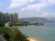
The Lantau Link that passes through Ma Wan was constructed in the mid-1990s as part of the Hong Kong Government's Rose Garden plan to connect the new Hong Kong International Airport to the city centre. Its development fostered plans to develop the island. Today, a large part of Ma Wan is occupied by the Park Island apartment complex. A theme park, named Ma Wan Park was built to accompany the housing project, with its first phase opened on 1 July 2007.
Gopro 2 hd ma wan abandoned village hong kong
GeographyEdit
Ma Wan has an area of 0.97 square kilometres (0.37 sq mi). It is 1.5 kilometres (0.93 mi) long and 1.3 kilometres (0.81 mi) wide. Its highest point is Tai Leng Tau (69 metres (226 ft)) in the southeast. Two channels separate Ma Wan and other major islands.
GeologyEdit
Ma Wan surface rocks are mostly volcanic rocks called Yim Tin Tsai Formation. This is a coarse ash crystal tuff containing lapilli. Some layers of fine volcanic ash are found in the far north of the island. The contained mafic minerals are biotite and amphibole. The tuff contains mostly quartz and alkali and plagioclase feldspar. Other minerals include apatite, magnetite, monazite and zircon.
The Ma Wan granite is fine grained. It contains microcline, and few feldspar phenocrysts. The main minerals are quartz, perthitic orthoclase, and plagioclase. The dark mineral is mostly biotite. Also contained is zircon, fluorite, and allanite. It is found on the south of the east coast.
Dykes formed later with a mafic dyke injected first followed by a felsic material. A feldsparphyric dyke crosses the island east-west near the ferry pier.
Several Cenozoic age quartzphyric rhyolite dykes cross the island. These are also injected with narrow dacitic dykes, and last of all very fine grained mafic basaltic dykes.
A north east trending fault crosses Ma Wan from the typhoon shelter on the west side to the Tun Wan. The island is separated from Lantau Island by a fault under the channel called the Kap Shui Mun Fault. This is angled to the North West, and has its direction controlled by the major tectonic zone it is in called the Linhua Shan Fault System that extends from the coast of Guangdong to Fujian.
Prominent joints are at 85° parallel to the dykes. Other joints are close to horizontal, can cause rocks to form sheets.
HistoryEdit
Remains have been found from the Mid-Neolithic Age (about 3000 BC), the late Neolithic Age (about 2000 BC), the early to late Bronze Age of coastal South China (1500-500 BC), the period of the Warring States to the Han Dynasty (206 BC -220 AD), the Tang Dynasty (618-917 AD) and the Qing Dynasty (1644-1911 AD).
Complete Neolithic human skeletal remains were found in tombs at Tung Wan Tsai in 1997. (Ref. The Antiquities and Monuments Office of the Home Affairs Bureau)
The prehistoric island had late neolithic inhabitants as proved by recent excavations. There were also inhabitants here during the Han Dynasty. More recently in the last 250 years it was a small fishing village named Tin Liu, only accessible by boats or ferries. It was founded by a Chan family from Tsing Yi island.
Ma Wan once had a Customs house, still recorded by a stone monument named "Kowloon Gate" monument. (see it near to the old Rural Committee). It ceased activity on 4 October 1899
Foreign visitors in 1794.
24 housing units donated by Americans in 1965 (see them on a top of a hill near to the Fishermen's association)
In the early 1970s, the island across from Ma Wan was occupied by three families. Their family names were Woo, Pang, and Woo. The children of these families attended the kindergarten and Fong Yuen School in Ma Wan. Water transportation to Ma Wan was signaled by waving a flag at the pier. The Woo family sustained a living by fishing and creating baskets. The Pang family sustained a living by raising chickens and ducks.
As of 1995, fish farming was the predominant economic activity on Ma Wan.
Ma Wan had a population of 800 in 2000. With the development of the Park Island apartment complex, villagers were rehoused in the northern part of the island. As part of the compensation package, they could choose either a 3-storey traditional village house of 2,100 square feet (0.048 acres) or 3 separate units, each of 700 square feet (65 m2) in one single block.
Park IslandEdit
Park Island is a private housing estate that was mainly developed by Sun Hung Kai Properties as part of the Ma Wan Development joint venture project and completed from 2002 to 2006 in six phases.
VillagesEdit
LeisureEdit
ReligionEdit
EducationEdit
CultureEdit
OthersEdit
InfrastructureEdit
RoadEdit
Although the Hong Kong government originally claimed it would be "physically impossible" to give the island a road connection via the Lantau Link, this was disproved with the beginning of construction of Park Island. The island is now connected to Tsing Yi by the Tsing Ma Bridge (a suspension bridge), and to Lantau Island by the Kap Shui Mun Bridge (a cable-stayed bridge). Both bridges are part of the Lantau Link.
Park Island Transport Co., Ltd. operates bus services from Park Island to Tsing Yi MTR Station, Kwai Fong Metroplaza, Hong Kong International Airport and Tsuen Wan (close to the Tsuen Wan MTR station).
Starting from 3 July 2008, urban taxi were permitted access into Ma Wan during between 8pm and 7am the following morning to meet residents' transport needs. Starting from 14 December 2012, urban taxi were permitted access into Ma Wan 24 hours daily.
Private vehicles are generally not permitted to enter the island, an arrangement which also exists in Discovery Bay on the nearby Lantau Island; however a permit can be requested from the Transport Department of Hong Kong. Minibuses are not allowed, but the Park Island management company operates cars in case of emergency or special situations, though their availability is not guaranteed. Lorries may enter the island between 10am to 4pm daily without the need for a special permit.
WaterEdit
There are several ferry piers on the island: Park Island Ferry Pier on the northeast, one on the old Tin Liu village on the west (formerly hosting Sham Tseng ferries), Man Wan Public Pier on the southwest at Ma Wan Main Street Village, Tai Pai Tsui Pier on the south of the island facing Tang Lung Chau, one on the north of the island used for the garbage removal, one on the southeast side (but on a Government land not open).
Park Island Transport Co., Ltd. operates ferry services between Park Island and Central Piers (Pier 2). Another route to Tsuen Wan Pier (near West Rail Tsuen Wan West Station) was discontinued on 13 December 2012 after 10 years of operation.