
 | ||
Similar Heng Fa Chuen, Diamond Hill, Taikoo Shing, Olympic Station, Ma Wan | ||
Transformers 4 to kwa wan 24th october 2013
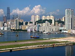
To Kwa Wan (traditional Chinese: 土瓜灣; simplified Chinese: 土瓜湾; pinyin: Tǔguāwān; Jyutping: tou2 gwaa1 waan1) is a bay and an area of the eastern shore of Kowloon peninsula. The area is part of urban Hong Kong, and is adjacent to Hok Yuen, Hung Hom, Ma Tau Wai and Ma Tau Kok. Administratively, the area belongs to the Kowloon City District of Kowloon.
Contents
To Kwa Wan is a mixed residential and commercial area, and is located to the west of the old Kai Tak Airport.
Most residential dwellings in the area are mid-rise flats of 10 or less floors, built in the mid-20th century. Newer buildings being built in or around To Kwa Wan are taller than 10 stories. Those flats built along major roads like Ma Tau Wai Road have commercial space on the ground floor.
Buildings along To Kwa Wan Road are mainly occupied by industry. Towngas has a storage facility in the northern part of To Kwa Wan.
In the 1970s public housing estates were built in the area to provide relief in other crowded areas of Kowloon.
Poor building standards and ageing have been highlighted by crumbling facades which have hurt and killed people in the area. The demolition of older flats have given means for developers to acquire land in To Kwa Wan to build newer and more profitable residential flats.
To kwa wan
Green Space
Alongside high-density residential and commercial zoning, there are a few green spaces in To Kwa Wan:
Hoi Sham Island, formerly located in the adjacent bay, was incorporated into the peninsula due to extensive reclamation, becoming Hoi Sham Park.
Transportation
There only a few main roads in the area. All other roads are side streets servicing local residents. To Kwa Wan Road and Ma Tau Wai Road form a V-shaped corridor, while the East Kowloon Corridor is an elevated highway passing through the middle of To Kwa Wan.
The Kowloon City Pier Bus Terminus to the north services some local bus routes.
When the Sha Tin to Central Link is built, Ma Tau Wai Station will serve the area. However this line will result in expropriation and demolition of many residential flats.
There is a ferry pier in To Kwa Wan (Kowloon City Pier). There are regular ferries (every 1/2 hour) operated by New World First Ferry to North Point.