
Existed: 1986 – present Constructed 1986 | Length 36.82 km | |
 | ||
Counties Wayne County, Michigan, Oakland County, Michigan | ||
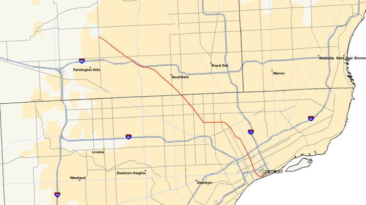
M-10 is a north–south state trunkline highway in the Metro Detroit area of Michigan in the United States. The southernmost portion follows Jefferson Avenue in downtown Detroit, and the southern terminus is at the intersection of Jefferson and M-3 (Randolph Street) next to the entrance to the Detroit–Windsor Tunnel. The northern terminus is in West Bloomfield Township at the intersection with Orchard Lake Road. The highway has several names as it runs through residential and commercial areas of the west side of Detroit and into the suburb of Southfield. It is called the John C. Lodge Freeway, The Lodge, James Couzens Highway and Northwestern Highway.
Contents
- Route description
- Detroit
- Oakland County
- Previous designations
- Current designation
- Memorial highway names
- References
M-10 was built in segments through the late 1950s and early 1960s. It carried several different names before the entire route was finally officially named the John C. Lodge Freeway in 1987. The freeway has carried a few other highway designations. The southern segment was part of US Highway 12 (US 12) and the whole thing was later renumbered Business Spur Interstate 696 (BS I-696). From 1970 until 1986, it was part of US 10, and the freeway has been M-10 since. The non-freeway segment that runs between I-696 in Southfield and Orchard Lake Road was previously numbered M-4. M-10 was named after John C. Lodge, an influential Detroiter and Mayor of Detroit from 1927–28.
Route description
Running about 22.8 miles (36.7 km) in the Metro Detroit area, M-10 runs roughly northwest–southeast from Downtown Detroit into the northern suburbs in Oakland County. The entire length of the highway is listed as a part of the National Highway System, a system of roads importance to the nation's economy, defense and mobility. As a state trunkline highway, the roadway is maintained by the Michigan Department of Transportation (MDOT), and it includes approximately 18.5 miles (29.8 km) of freeway. M-10 has six lanes from Detroit to Inkster Road in Farmington Hills, where it drops to four; a few segments have eight lanes for short distances between interchanges. According to the department, 28,964 vehicles use M-10 on average near on Jefferson Avenue in Detroit, and 139,800 vehicles do so between US 24 (Telegraph Road) and Lahser Road in Southfield, the lowest and highest traffic counts along the highway in 2013, respectively.
Detroit
M-10 starts at the corner of Jefferson Avenue and Randolph Street in Downtown Detroit, an intersection that also marks the southern end of M-3 and the western end of Business Spur I-375. This intersection is also the access to the Detroit–Windsor Tunnel between the Renaissance Center and the Old Mariners' Church. From here, M-10 runs west-southwesterly parallel to the Detroit River on Jefferson Avenue past Hart Plaza. At the intersection with Woodward Avenue, M-10 transitions onto the John C. Lodge Freeway, which runs under Cobo Center, home of the North American International Auto Show each January. The freeway turns north-northwesterly and away from the Detroit River next to Joe Louis Arena. North of the Cobo Center curve, M-10 forms the boundary between Downtown Detroit to the east and the Corktown neighborhood to the west. The freeway has a pair of service drives as it leaves the commercial areas near the MGM Grand Detroit and the interchange with I-75 (Fisher Freeway).
North of I-75, M-10 forms the border between North Corktown (west) and Midtown Detroit (east). The freeway passes the MotorCity Casino at the interchange with Grand River Avenue. The rest of its route in the part of the city passes through residential zones. Near the interchange with I-94 (Edsel Ford Freeway), M-10 passes the campus of Wayne State University. M-10 intersects I-94 at the first freeway-to-freeway interchange in the United States. North of I-94, the Lodge Freeway is the border between the West Side and New Center . This area is residential on either side of the freeway north of the campus of the Henry Ford Hospital. North of Clairmont Avenue, M-10 curves to the northwest before resuming its north-northwesterly course near Chicago Boulevard. North of Webb Avenue, the freeway follows the western city limits of Highland Park, an enclave within the city of Detroit. M-10 intersects M-8 where it transitions between Davison Avenue and the Davison Freeway on the western edge of Highland Park before the Lodge Freeway curves around to run due west.
M-10 runs for about two miles (3.2 km) on this due westward course before it intersects Wyoming Avenue and turns northwest. The frontage roads change names from John C. Lodge Service Drive to James Couzens Freeway at the Wyoming Avenue interchange. The freeway continues for another 3 1⁄2 miles (5.6 km) with interchanges for local streets in this part of Detroit, including 7 Mile Road. At the interchange with M-102 (8 Mile Road), the freeway crosses out of Detroit and Wayne County into Southfield in Oakland County.
Oakland County
The service drives change names again to Northwestern Highway upon crossing into Oakland County. The east side of M-10 is flanked by the Northland Shopping Center and a campus of Oakland Community College; the west side is residential. About 1 1⁄4 miles (2.0 km) into Southfield, M-10 intersects the northern end of M-39 (Southfield Freeway) and 9 Mile Road. The adjacent properties are mostly residential, but there are some commercial areas centered around the various Mile Roads, such as the campus of Lawrence Technological University at 10 Mile Road. Near Lahser and 11 Mile roads, M-10 meets I-696 (Reuther Freeway) and US 24 (Telegraph Road) in a complex interchange called the Mixing Bowl. This interchange spans over two miles (3.2 km) near the American Center. The carriageways for I-696 run in the median of M-10 while partial interchanges connect to Lahser and Franklin roads on either end of the various ramps that connect to I-696 and US 24.
Northwest of this interchange, M-10 transitions to a boulevard with Michigan lefts. Called just Northwestern Highway, M-10 runs through suburban residential areas of Southfield. At the intersection with Inkster Road, the highway clips the southwest corner of the city of Franklin and enters the northeastern corner of Farmington Hills. The roadway is lined with commercial properties while just behind them are residential subdivisions and two golf courses. At the intersection with 14 Mile Road, Northwestern Highway crosses into West Bloomfield Township, and 1⁄4 mile (0.40 km) further on, the highway ends at Orchard Lake Road.
Previous designations
In 1919, the state numbered its highways for the first time. In the initial allocation of numbers, M-10 was assigned to a highway that started at the Ohio state line south of Monroe, ran northeasterly along Telegraph Road into Dearborn and turned easterly into Detroit. From there, the highway turned north along Woodward Avenue through Pontiac and Dixie Highway through Flint and Saginaw to Bay City. Then M-10 ran along the Saginaw Bay to Standish and turned to follow the Lake Huron shoreline, with some substantial deviations inland. The highway generally followed the lakeshore as far north as Alpena and Rogers City, and from there, M-10 ran due west through Onaway before turning north into Cheboygan. The last section of M-10 followed the Lake Huron shoreline to Mackinaw City, where it terminated. This designation lasted until November 11, 1926, when the United States Numbered Highway System was created. In Michigan's initial allocation of highways, four new designations replaced M-10: US 24 from the state line north to Dearborn, US 112 between Dearborn and Detroit, US 10 from Detroit to Saginaw, and US 23 from Saginaw to Mackinaw City. At the time, no M-10 designation was reassigned to any other roads.
The second iteration of M-10 was designated in 1929 on a much shorter segment of the original M-10 through the Flint area, serving as a business connection for the city as the through route, US 10, bypassed it on the east. It was later redesignated as Business US 10 (Bus. US 10) in 1941, and then as Bus. M-54 in 1962 before being turned back to local control in 1974.
Current designation
During the 1950s, the Lodge Freeway was proposed to run from Detroit as far as the Fenton–Clio Expressway (US 23) at Fenton. The intersection with the Edsel Ford Freeway, next to Wayne State University was built in 1953 and was the first full freeway-to-freeway interchange built in the United States. The freeway was dedicated on November 7, 1957, and opened without any state trunkline designation between downtown and the Wyoming Curve. The section from the Edsel Ford Freeway (now I-94) into downtown Detroit was designated as US 12 by the middle of 1960.
The freeway was then redesignated Business Spur I-696 (BS I-696) in 1962, and the next year the freeway was extended northwesterly along James Couzens Highway and Northwestern Highway into Southfield, connecting with the completed first phase of I-696 that opened in 1963-64. That designation remained until 1970 when US 10 was shifted off Woodward Avenue to follow the Lodge Freeway between downtown Detroit and Telegraph Road, replacing the BS I-696 designation.
An extension to the Northwestern Highway was again proposed in 1966 to connect with the proposed I-275 extension. The I-275 project was then cancelled in 1977. The section of Northwestern Highway under state control between the West Bloomfield Township–Farmington Hills border into Southfield was numbered M-4 in 1979.
The Michigan Department of Transportation (MDOT) petitioned the American Association of State Highway and Transportation Officials in the mid-1980s to truncate US 10 to Bay City. The request was approved on October 11, 1985, and the signage was changed the next year. After the change, the Lodge Freeway was redesignated M-10. The non-freeway Northwestern Highway, until then designated M-4, was also renumbered as M-10. The southernmost portion of the Lodge Freeway was also initially redesignated as a portion of BS I-375 from I-75 south. By the next year however, the southern end of M-10 was moved to the corner of Jefferson and Randolph, placing all of the Lodge Freeway as part of M-10.
From 2006 to 2007, the Lodge underwent major reconstruction to ease traffic congestion in the metro area, temporarily closing down much of the freeway. The $133 million project (equivalent to $155 million in 2015) included concrete pavement reconstruction and rehabilitation, new barrier walls, repairs or replacements to 50 bridges, upgrades to 22 ramps, utility upgrades, and replacement of freeway signs between Lahser Road in Southfield and Jefferson Avenue in Detroit.
Memorial highway names
Starting in 1924, officials in southeastern Michigan proposed building a highway from Detroit to run northwesterly across the state to Ludington, bisecting the angle created by Woodward and Grand River avenues. This roadway was named Northwestern Highway when it was built in 1929 to an endpoint at 14 Mile Road. Further construction on Northwestern Highway was halted by the Great Depression.
The freeway segment northwest of Wyoming Avenue to the county line was previously known as James Couzens Highway after the street it replaced. That street was named after the death of James J. Couzens. Couzens was a former Commissioner of Detroit's Department of Street Railways from 1913 through 1915, after which he served as Police Commissioner from 1916 until 1918. He was Mayor of Detroit from 1919 until 1922 and United States Senator from Michigan from 1922 until his death on October 22, 1936. During his years of public service, he is said not to have accepted a salary, giving it all to charity. After his death, Detroit renamed its section of Northwestern Highway after Couzens.
John C. Lodge was a member of the constitutional convention which drafted the Michigan Constitution of 1908, a former member of the Michigan Legislature and Detroit alderman and councilman. He later served as Mayor of Detroit in 1918–1919 before returned to the City Common Council from 1932 to 1947. He was then elected to the Wayne County Board of Supervisors from 1948 until 1950. In total, he held elective office longer than anyone in city history. He died on February 6, 1950, and the future Lodge Freeway was named in his honor on January 20, 1953. The entire freeway, including segments previously named for James Couzens and the Northwestern Highway was named the John C. Lodge Freeway in 1987, although the service drives retained their original names.