
Country Area 91.26 km2 | ||
 | ||
District Urban districts of Germany | ||
Short tour in mulheim an der ruhr germany
Mülheim an der Ruhr ( [ˈmyːlhaɪm ʔan deːɐ̯ ˈʁuːɐ̯]), also described as "City on the River", is a city in North Rhine-Westphalia in Germany. It is located in the Ruhr Area between Duisburg, Essen, Oberhausen and Ratingen. It is home to many companies, especially in the food industry, such as the Aldi Süd Company, the Harke Group and the Tengelmann Group.
Contents
- Short tour in mulheim an der ruhr germany
- Map of Mlheim
- Mulheim an der ruhr impressionen in hd
- Geographical location
- Geology
- Transport
- International relations
- Notable bands
- Notable clubs
- Notable companies
- Notable people
- References
Map of Mülheim
Mülheim received its town charter in 1808, and 100 years later the population exceeded 100,000, making Mülheim officially a city. At the time of the city's 200th anniversary with approximately 170,000 residents, it was counted among the smaller cities of Germany.
Mülheim was the first city in the Ruhr Area to become completely free of coal mines, when its last coal mine "Rosenblumendelle" was closed. The former leather and coal city had successfully made a complete transformation to a diversified economic centre. With more than 50% covered by greenery and forest, the city is regarded as an attractive place to live between Düsseldorf and the rest of the Ruhr. It is the home of two Max Planck Institutes and, since 2009, the technical college Ruhr West. It has a station on the important railway between Dortmund and Duisburg and is served by Rhine-Ruhr S-Bahn lines S1 and S3.
Mulheim an der ruhr impressionen in hd
Geographical location
Mülheim an der Ruhr lies at the junction of the hill country of the Lower Bergisches Land, the western Hellweg and the plane of the middle Lower Rhine region.
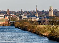
The Ruhr leaves the foothills of the Rhenish Massif and enters the Lower Rhine Plain at Mulheim. The Ruhr flows through the city from south-east to north-west for a distance of 14 km (9 miles) dividing it into two districts: Broich on its left (western) bank and Kirchenhügel (Church Hill) on its right (east) bank. The central city lies on both banks of the river, about 12 kilometres (7 miles) east of where the Ruhr discharges into the Rhine. Life in Mulheim is intermediate between the more urban, downstream, Düsseldorf and the more rural life of the upstream Ruhr.
Geology
The northern foothills of the Rhenish Massif are characterised by the distinctive rock formation of the bare mountain slopes through which run coal-bearing layers which formed during the carboniferous period. Here the Ruhr cuts more than 50 meters deep into this Mittelgebirge. This natural erosion partly uncovered these mineable black coal deposits, which enabled their exploration and extraction using adits. However, the coal-rich layers became ever deeper as one progressed northward, which required setting up mines to extract the black coal. In contrast, the broad bayou (dead arm of a river) of Styrum borough is characteristic of the features of the Lower Rhine Plain.
Transport
The U18 metro line connects the city with Essen.
International relations
Mülheim is twinned with: