
Country United States Time zone Pacific (PST) (UTC-8) Elevation 542 m Zip code 92338 Area code 760 | State California Founded 1883 ZIP codes 92338 Population 10 (2000) Local time Tuesday 10:01 AM | |
 | ||
Weather 23°C, Wind NW at 3 km/h, 22% Humidity | ||
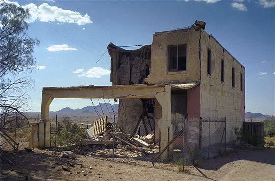
Ludlow is an unincorporated community in the Mojave Desert on Interstate 40, located in San Bernardino County, California, United States. The older remains of the ghost town are along historic Route 66.
Contents
Map of Ludlow, CA 92338, USA
Geography
To the northwest on Interstate 40 are Newberry Springs and Barstow, California. To the east on Route 66 is Amboy, Amboy Crater, and Essex, and on Interstate 40 is Needles, California and the Colorado River.
The Mojave National Preserve and Kelso Dunes, of the National Park Service, is to the northeast of town. To the west is Pisgah Crater in the Lavic Lake volcanic field. The Bullion Mountains are south behind the town, with the Bristol Mountains to the east and Cady Mountains to the northwest..
The Ludlow ZIP Code is 92338, and the community is in telephone area code 760.
Climate
This area has a large amount of sunshine year round due to its stable descending air and high pressure. According to the Köppen Climate Classification system, Ludlow has a mild desert climate, abbreviated "Bwh" on climate maps.
Origins
The town started as a water stop for the Atlantic and Pacific Railroad in 1883. Ore was found in the nearby hills, leading to a boom. From 1906 to 1940 it was the southern railhead for the Tonopah and Tidewater Railroad, operated by the Pacific Coast Borax Company and bringing borax and other mining products from Death Valley and Beatty, Nevada to long distance Santa Fe Railway lines.
Route 66
By the 1940s, local mining and railway activity had ceased and the town survived supplying the needs of travellers on the National Old Trails Road, renamed to become the legendary Route 66 in California. Ludlow providing a Motor Court with bungalow cabins, the streamline moderne Ludlow Cafe, a gasoline-service garage, and shade. They operated through the late 1960s. After Interstate 40 was built bypassing town there was little business and most residents departed, leaving ruins of empty buildings and Tamarisk trees that still stand flanking the old highway. Tourists following and exploring historic Route 66 pass through the ghost town now.
Interstate 40
A small "New Ludlow" just to the north at the off-ramps of Interstate 40 was built in the 1970s, and contains two gas stations and a small tire and repair shop, a small motel, and a restaurant and fast-food café.
On January 25, 2014, a truck carrying 76,000 pounds (34,000 kg) of beef ribs caught fire on Interstate 40, blocking westbound traffic for two hours. A San Bernardino County Fire spokesman stated that the fire had "a wonderful BBQ beef rib odor."
Media
In 2015, Ludlow was one of the filming locations for the film Sky as well as Barstow, Bombay Beach, Hinkley, Joshua Tree, Landers, Lenwood, Newberry Springs, and Victorville, California.