
Length 248.8 km | ||
 | ||
Existed: August 7, 1947 by FHWAJuly 1, 1964 by Caltrans – present | ||
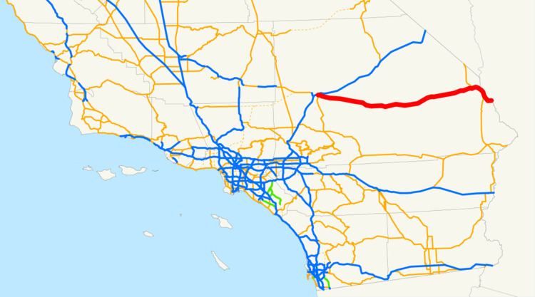
In the State of California, Interstate 40 (I-40) begins on the west at its interchange with Interstate 15 in Barstow. Sometimes called the Needles Freeway, it is a major east—west highway of the Interstate Highway System that goes all the way to Wilmington, North Carolina. I-40 goes east from Barstow across the Mojave Desert in San Bernardino County past the Clipper Mountains to Needles, before it crosses over the Colorado River into Arizona east of Needles. All 155 miles of I-40 in California are in San Bernardino County.
Contents
Route description
This route is part of the California Freeway and Expressway System and is eligible for the State Scenic Highway System. However, it is not a scenic highway as designated by Caltrans. Interstate 40 from Interstate 15 to the Arizona State Line is known as the Needles Freeway, as named by Senate Concurrent Resolution 1 in 1968. Interstate 40 goes through the Mojave Desert on its entire journey through California.
I-40 starts out at a junction with Interstate 15 in Barstow. The freeway passes through Marine Corps Logistics Base Barstow before leaving the city limits. I-40 provides access to the town of Daggett but passes south of the town. After passing south of the Barstow-Daggett Airport, I-40 goes through Newberry Springs and Ludlow before traveling along the south end of Mojave National Preserve. Several miles east of the preserve, I-40 intersects US 95 and the two highways run concurrently into the city of Needles. In Needles, US 95 continues south while I-40 continues east through Mojave National Preserve and across the Colorado River into Arizona.
The maximum speed limit for the entire California segment of Interstate 40 is 70 mph (110 km/h).
History
The segment of I-40 in California was approved as a chargeable Interstate on July 7, 1947. In 1957, the California Department of Highways proposed that the route be renumbered to Interstate 30 instead because of the already existing U.S. Route 40 in the state. However, this was rejected, and eventually U.S. 40 was decommissioned in favor of Interstate 80.
Today, the Needles Freeway replaced the former Route 66 across the Mojave Desert. As a result, a number of communities along the former route like Amboy have become ghost towns.
In the early 1960s, a proposal as part of Operation Plowshare would have detonated 22 nuclear explosions to excavate a massive roadcut through the Bristol Mountains to accommodate a better alignment of Interstate 40 and a new rail line. This proposal was definitively abandoned in 1968.
A sign in California showing the distance to Wilmington, North Carolina has been stolen several times.
Future
The State of California submitted the segment of what is now State Route 58 between Barstow and Bakersfield for chargeable Interstate approval twice, in 1956 and 1968, presumably as an extension of I-40, but it was rejected both times. As a result of these rejections, this segment of SR 58 is being upgraded to freeway standards piece-by-piece as Caltrans has funds available. Between Bakersfield and Barstow, SR 58 exists mostly as freeway with a few exceptions: a 12-mile (19 km) section from Mojave to California City is four lanes with at-grade intersections, and a 33-mile (53 km), two-lane section from west of Kramer Junction, through Hinkley, to Barstow. Caltrans is currently constructing an Interstate-grade bypass around Hinkley and has plans in place to construct a similar bypass around Kramer Junction when funding becomes available. Completion of the bypasses around Hinkley and Kramer Junction would leave the Mojave–California City segment of SR 58 as the last remaining non-freeway section between Barstow and Bakersfield. However, there is no current push to apply for Interstate designation.
Exit list
The entire route is in San Bernardino County.
Needles business loop
Interstate 40 Business is a business loop in Needles. It provides access to downtown Needles as Broadway Street. It also follows the former routing of US 66.