
Country United States County Imperial Area codes 442/760 Elevation -68 m Population 295 (2010) | State California FIPS code 06-07372 Area 244 ha Zip code 92257 | |
 | ||
Bombay Beach is a census-designated place (CDP) in Imperial County, California, United States. It is located on the Salton Sea 4 miles (6.4 km) west-southwest of Frink and is the lowest community in America, located 223 feet (68 m) below sea level. The population was 295 at the 2010 census, down from 366 in 2000. It is part of the El Centro, California Metropolitan Statistical Area.
Contents
- Map of Bombay Beach CA 92257 USA
- Geography
- 2010
- 2000
- Government
- General information
- Influence
- Media appearances
- References
Map of Bombay Beach, CA 92257, USA
Geography
Bombay Beach is located at 33°21′03″N 115°43′47″W.
According to the United States Census Bureau, the CDP has a total area of 0.9 square miles (2.3 km2), all land.
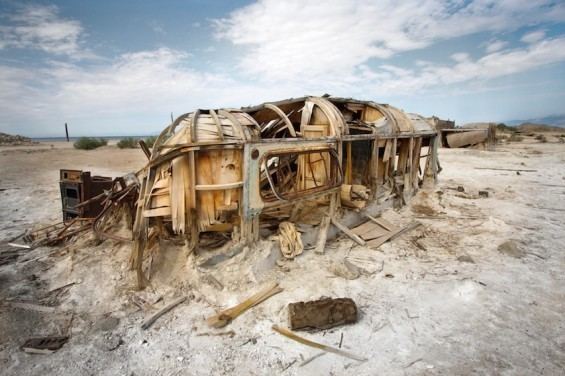
Bombay Beach is located on the east shore of the Salton Sea and like many communities along its shores, has had to contend with fluctuating water levels. A berm now protects the west end of the town, but a portion of the town beyond the berm is either submerged or is half-buried in mud. The town of Bombay Beach is located in Southern California's Sonoran Desert.
Bombay Beach marks the southern end of the San Andreas fault.
2010
The 2010 United States Census reported that Bombay Beach had a population of 295. The population density was 313.5 people per square mile (121.0/km²). The racial makeup of Bombay Beach was 223 (76%) White, 37 (13%) African American, 8 (3%) Native American, 1 (0%) Asian, 0 (0%) Pacific Islander, 22 (8%) from other races, and 4 (1%) from two or more races. Hispanic or Latino of any race were 59 persons (20%).
The Census reported that 295 people (100% of the population) lived in households, 0 (0%) lived in non-institutionalized group quarters, and 0 (0%) were institutionalized.
There were 175 households, out of which 19 (11%) had children under the age of 18 living in them, 51 (29%) were married couples living together, 13 (7%) had a female householder with no husband present, 4 (2%) had a male householder with no wife present. There were 7 (4%) unmarried partnerships, and 1 (1%) same-sex married couples or partnerships. 97 households (55%) were made up of individuals and 51 (29%) had someone living alone who was 65 years of age or older. The average household size was 1.69. There were 68 families (39% of all households); the average family size was 2.54.
The population was spread out with 30 people (10%) under the age of 18, 16 people (5%) aged 18 to 24, 36 people (12%) aged 25 to 44, 98 people (33%) aged 45 to 64, and 115 people (39%) who were 65 years of age or older. The median age was 58.5 years. For every 100 females there were 113.8 males. For every 100 females age 18 and over, there were 108.6 males.
There were 449 housing units at an average density of 477.1 per square mile (184.2/km²), of which 115 (66%) were owner-occupied, and 60 (34%) were occupied by renters. The homeowner vacancy rate was 15%; the rental vacancy rate was 16%. 198 people (67% of the population) lived in owner-occupied housing units and 97 people (33%) lived in rental housing units.
2000
As of the census of 2000, there were 366 people, 178 households, and 93 families residing in the CDP. The population density was 363.8 people per square mile (139.9/km²). There were 440 housing units at an average density of 437.4 per square mile (168.2/km²). The racial makeup of the CDP was 71% White, 19% Black or African American, 1% Native American, 0% Asian, 4% from other races, and 5% from two or more races. 19% of the population were Hispanic or Latino of any race.
There were 178 households out of which 18% had children under the age of 18 living with them, 39% were married couples living together, 11% had a female householder with no husband present, and 47% were non-families. 40% of all households were made up of individuals and 26% had someone living alone who was 65 years of age or older. The average household size was 2 and the average family size was 2.8.
In the CDP, the population was spread out with 18% under the age of 18, 3% from 18 to 24, 20% from 25 to 44, 26% from 45 to 64, and 33% who were 65 years of age or older. The median age was 53 years. For every 100 females there were 92.6 males. For every 100 females age 18 and over, there were 99.3 males.
The median income for a household in the CDP was $17,708, and the median income for a family was $19,511. Males had a median income of $31,250 versus $14,213 for females. The per capita income for the CDP was $10,535. About 12% of families and 28% of the population were below the poverty line, including 40% of those under age 18 and 14% of those age 65 or over.
Government
In the California State Legislature, Bombay Beach is in the 40th Senate District, represented by Democrat Ben Hueso, and the 56th Assembly District, represented by Democrat Eduardo Garcia. In the United States House of Representatives, Bombay Beach is in California's 51st congressional district, represented by Democrat Juan Vargas.
General information
Most residents use golf carts to get around, since the nearest gas station is 20 miles (32 km) away in Niland.
The ruins of Bombay Beach attract many photographers and visitors. The town, as well as others on the shores of the Salton Sea, is one of the lowest settlements in altitude in North America. The Ski Inn is the only drinking establishment or bar in the town.
Influence
Florian Ayala Fauna of the music duo uncertain grew up in Bombay Beach, California. Fauna credits the place as an inspiration to her music. In an interview with Buffalo, New York alternative newspaper The Public's Cory Perla, Fauna described it as "a very kind of post-apocalyptic-looking town."