
Country United States Length 3,200 ft (980 m) Opened 1975 Construction cost 624.1 million USD | Opening date June 1975 Height 30 m Create Lower Granite Lake Construction began July 1965 | |
 | ||
Similar | ||
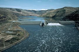
Locking down at lower granite dam
Lower Granite Lock and Dam is a concrete gravity run-of-the-river dam in the northwest United States. On the lower Snake River, it bridges Whitman and Garfield counties in southeastern Washington. The dam is located 22 miles (35 km) south of the town of Colfax, and 35 miles (56 km) north of Pomeroy.
Contents
- Locking down at lower granite dam
- Map of Lower Granite Dam Washington 99113 USA
- Sturgeon fishing lower granite dam 2014
- ConstructionEdit
- FisheryEdit
- Asotin DamEdit
- Road closedEdit
- References
Map of Lower Granite Dam, Washington 99113, USA
Lower Granite Dam is part of the Columbia River Basin system of dams. It was built and is operated by the United States Army Corps of Engineers. Power generated is distributed by the Bonneville Power Administration.
Lower Granite Lake, which extends 39 miles (63 km) east to Lewiston, Idaho, is formed behind the dam, and allowed the city to become a port. Lake Bryan, formed from Little Goose Dam, runs 37 miles (60 km) downstream from the base of the dam.
Sturgeon fishing lower granite dam 2014
ConstructionEdit
Construction began in July 1965, but was halted less than two years later due to lack of funding. Work restarted in 1970, concrete was first poured in 1971, and the main structure and three generators were completed in 1975. An additional three generators were finished in May 1978, bringing the generating capacity to 810 megawatts, with an overload capacity of 932 MW. The spillway has eight gates and is 512 feet (156 m) long. An 86-by-674-foot (26 m × 205 m) navigation lock was also included in construction.
FisheryEdit
Lower Granite Dam is the most upstream dam in the Snake River system that has a fish ladder to allow adult salmon and steelhead to migrate upstream. The Columbia River treaty tribes along with some environmental groups have recommended that this dam along with the other three lower Snake River dams be decommissioned and/or removed because of their impact on threatened and endangered chinook (threatened) and sockeye salmon (endangered) and steelhead (threatened) populations., A significant increase in the Sockeye Salmon return to the Columbia River in 2008 proved a pleasant surprise and raised hopes for increased salmon runs across the Lower Granite. Wildlife officials were not certain of the reason for the increased salmon return (Idaho Statesman, June 28, 2008) The Army Corps of Engineers has installed new devices such as removable spillway weirs in an attempt to make the dam less harmful to juvenile salmon.
There is also a juvenile bypass/collection facility that collects juvenile migrating salmon and steelhead so they can be transported downstream by barge.
Asotin DamEdit
Authorized by Congress in 1962, a fifth dam on the lower Snake River was proposed several miles upstream of Lewiston. Concerns over its environmental and recreational impact stalled the Asotin Dam project, and it was ultimately canceled in 1980. The Asotin County public utilities district attempted to revive the project in 1988, but it was quickly blocked by Congress, and a law banning future dams was signed into law by President Reagan on November 17.
Other proposed dams further upstream were not built either: the High Mountain Sheep Dam above the confluence with the Salmon River, and the Nez Perce Dam, just below it.
Road closedEdit
Following the September 11 attacks in 2001, the road across the Lower Granite Dam was closed for over six years; it reopened for weekend traffic in May 2008. The sand dune area downstream on the south shore (46.696°N 117.48°W / 46.696; -117.48), accessed over the dam, was popular with local college students from Washington State University and the University of Idaho.