
 | ||
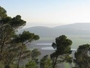
Landscape of the lower galilee near nazareth and zippori israel
The Lower Galilee (Hebrew: הגליל התחתון, translit. HaGalil HaTaḥton), is a region within the Northern District of Israel. The Lower Galilee is bordered by the Jezreel Valley to the south; the Upper Galilee to the north, from which it is separated by the Beit HaKerem Valley; the Jordan Rift Valley with the Jordan River and the Sea of Galilee to the east; and to the west, a segment of the Northern Coastal Plain known as the Zebulon (Zvulun) Valley, stretching between the Carmel ridge and Acre. The Lower Galilee is the southern part of the Galilee. It's called "Lower" since it is less mountainous than the Upper Galilee. The peaks of the Lower Galilee rise to 500 meters above sea level. The tallest peaks are Mount Kamon (598 m) at the northern part of the Lower Galilee and Mount Tabor (588 m) in the southern part.
Contents
- Landscape of the lower galilee near nazareth and zippori israel
- Map of Lower Galilee Israel
- Tomb of jethro nabi shu ayb in the lower galilee of israel
- Geography
- Type of soil
- References
Map of Lower Galilee, Israel
Tomb of jethro nabi shu ayb in the lower galilee of israel
Geography
The Lower Galilee consists of three different regions which differ in their geological structure:
The central Lower Galilee consists of low mountain ranges which extend from east to west with several valleys in between; south of the Beit Kerem (Šagor) Valley is the Shagor mountain range, then Sakhnin valley, Yodfat range, Beit Netofa Valley, Tur'an valley and range, Nazareth range, and Ksulot (Joshua 19:18) valley. In the western part of the Lower Galilee there are several low hills (200–300 meters) covered with Oak tree forests, the central Lower Galilee region is more mountainous and the eastern Lower Galilee region turn into flat basalt mountainside reaching heights of 300 meters above sea level which extend from northeast to the southwest.
Although the landscape of the Lower Galilee is less dramatic than that of the Upper Galilee, it is greener, more peaceful and quiet. The Lower Galilee is more accessible to the majority of Israelis (less than a 2 hour drive from the Tel Aviv area). Much of the produce farms of Israel originates in the Lower Galilee, especially in the Jezreel Valley and the Beit She'an Valley.
Type of soil
The soil of the Lower Galile mainly consists of the following: