
 | ||
Southeast Georgia's Lower Coastal Plain is a subregion that encompasses the lowest-lying areas of the Atlantic coastal plain in the state, containing barrier islands, marshes, and swampy lowlands, as well as flat plains and low terraces. It differs from Georgia's Upper Coastal Plain in that it is lower in elevation with less relief and wetter soils. The United States Environmental Protection Agency defines the Lower Coastal Plain as an ecoregion, part of the larger, interstate Southern Coastal Plain.
Within the subregion flow the major rivers the Altamaha, Ogeechee, Saint Marys, Savannah, Satilla, and Suwannee (all of which, except the Suwannee River, empty into the Atlantic Ocean); the Saint Marys and Suwannee rivers have their origins in the Okefenokee Swamp.
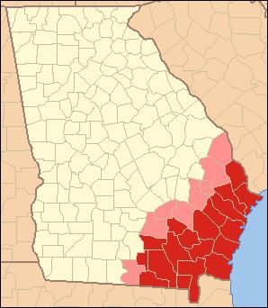
The subregion is synonymous with coastal Georgia, and contains the counties of Atkinson, Bacon, Brantley, Camden, Charlton, Clinch, Echols, Glynn, Lanier, Pierce, Ware, and Wayne, south of the Altamaha River; and Bryan, Chatham, Effingham, Liberty, Long, and McIntosh, north of the Altamaha River. The three metropolitan areas are those of Brunswick, Hinesville–Fort Stewart, and Savannah. The largest census county divisions, in the order of decreasing population, are Savannah, Hinesville, Pooler–Bloomingdale, Brunswick, Saint Marys, Waycross, Jesup, Richmond Hill, Tybee Island, and Everett. The total population of the eighteen-county subregion is 726,132 (286,271 south of, and 439,861 north of, the Altamaha River), as of the 2010 U.S. census.