
Founded 5 February 1777 | Area 1,562 km² Population 64,135 (2013) Unemployment rate 6.3% (Apr 2015) | |
 | ||
Website www.libertycountyga.com Rivers Taylors Creek, Blackbeard Creek, Long Branch | ||
Liberty County is a county located in the U.S. state of Georgia. As of the 2010 census, the population was 63,453. The county seat is Hinesville.
Contents
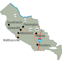
- Map of Liberty County GA USA
- History
- Geography
- Adjacent counties
- 2000 census
- 2010 census
- Cities
- Census designated place
- Unincorporated community
- In the media
- References
Map of Liberty County, GA, USA
Liberty County is part of the Hinesville, Georgia Metropolitan Statistical Area, which is also included in the Savannah-Hinesville-Statesboro, Georgia Combined Statistical Area.
History
Liberty county was established in 1777. It is named for the popular American ideal of liberty. Sunbury was first designated the county seat in 1784. In 1797, the seat was transferred to Riceboro and in 1837 it was transferred again to Hinesville.
Geography
According to the U.S. Census Bureau, the county has a total area of 603 square miles (1,560 km2), of which 490 square miles (1,300 km2) is land and 113 square miles (290 km2) (18.7%) is water.
The eastern and southern portion of Liberty County is located in the Ogeechee Coastal sub-basin of the Ogeechee River basin. The northern and western portion of the county is located in the Canoochee River sub-basin of the Ogeechee River basin.
Adjacent counties
2000 census
As of the census of 2000, there were 61,610 people, 19,383 households, and 15,138 families residing in the county. The population density was 119 people per square mile (46/km²). There were 21,977 housing units at an average density of 42 per square mile (16/km²). The racial makeup of the county was 46.64% White, 42.84% Black or African American, 0.52% Native American, 1.76% Asian, 0.43% Pacific Islander, 4.43% from other races, and 3.37% from two or more races. 8.15% of the population were Hispanic or Latino of any race.
According to 2005 Census Estimates Liberty County had a population that was 44.5% African-American, 44.4% Non-Hispanic white, 7.2% Latino, 3.1% non-Hispanics who reported multiple races, 1.9% Asian and 0.5% of both Native Americans and Pacific Islanders.
There were 19,383 households out of which 50.50% had children under the age of 18 living with them, 59.60% were married couples living together, 14.80% had a female householder with no husband present, and 21.90% were non-families. 16.60% of all households were made up of individuals and 3.20% had someone living alone who was 65 years of age or older. The average household size was 2.93 and the average family size was 3.29.
In the county, the population was spread out with 32.00% under the age of 18, 17.90% from 18 to 24, 33.90% from 25 to 44, 12.20% from 45 to 64, and 3.90% who were 65 years of age or older. The median age was 25 years. For every 100 females there were 111.30 males. For every 100 females age 18 and over, there were 115.10 males.
The median income for a household in the county was $33,477, and the median income for a family was $35,031. Males had a median income of $25,305 versus $20,765 for females. The per capita income for the county was $13,855. About 13.50% of families and 15.00% of the population were below the poverty line, including 19.20% of those under age 18 and 19.90% of those age 65 or over.
2010 census
As of the 2010 United States Census, there were 63,453 people, 22,155 households, and 16,566 families residing in the county. The population density was 129.5 inhabitants per square mile (50.0/km2). There were 26,731 housing units at an average density of 54.6 per square mile (21.1/km2). The racial makeup of the county was 47.1% white, 42.2% black or African American, 2.0% Asian, 0.6% Pacific islander, 0.6% American Indian, 2.9% from other races, and 4.7% from two or more races. Those of Hispanic or Latino origin made up 9.7% of the population. In terms of ancestry, 8.8% were German, 6.9% were Irish, and 6.0% were American.
Of the 22,155 households, 45.9% had children under the age of 18 living with them, 49.0% were married couples living together, 21.5% had a female householder with no husband present, 25.2% were non-families, and 20.7% of all households were made up of individuals. The average household size was 2.75 and the average family size was 3.18. The median age was 27.9 years.
The median income for a household in the county was $42,674 and the median income for a family was $46,818. Males had a median income of $35,881 versus $31,159 for females. The per capita income for the county was $18,662. About 15.0% of families and 17.8% of the population were below the poverty line, including 26.2% of those under age 18 and 13.4% of those age 65 or over.
Cities
Census-designated place
Unincorporated community
In the media
The 2014 award-winning Independent film, A Promise, was filmed in Liberty County.