
Length 695.6 km | ||
 | ||
Existed: 1955 renumbering – present | ||
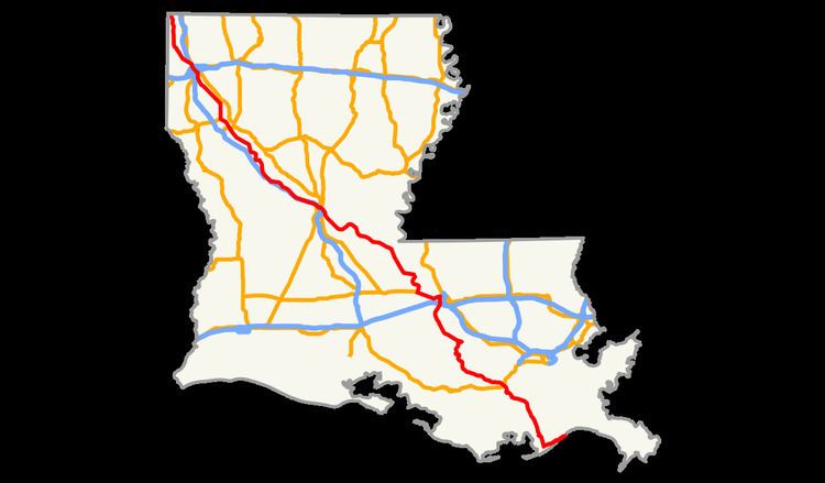
Louisiana Highway 1 (LA 1) is a state highway in Louisiana. At 432.2 miles (695.6 km), it is the longest numbered highway of any class in Louisiana. It runs diagonally across the state, connecting the oil and gas fields near the island of Grand Isle with the northwest corner of the state, north of Shreveport.
Contents
- Map of LA 1 Louisiana USA
- Route description
- Highway 1 elevated toll expressway
- Future
- Louisiana Highway 1 Business Natchitoches
- Louisiana Highway 1 Business New Roads
- References
Map of LA-1, Louisiana, USA
The part south of U.S. Highway 90 near Raceland is Corridor 44, a National Highway System High Priority Corridor. From Alexandria to Shreveport, the LA 1 corridor was used for Interstate 49.
Between New Roads, Louisiana, and the interchange with Interstate 49 at Alexandria, Louisiana, LA 10 forms part of the Zachary Taylor Parkway.
Route description
The southern terminus of LA 1 (29.2603°N 89.9637°W / 29.2603; -89.9637) is at a dead end in Grand Isle on the south bank of Bayou Rigaud. It heads southwest and west through Grand Isle, turning northwest where it meets LA 3090 (the road to Port Fourchon). At Leeville the road crosses Bayou Lafourche on the Leeville Bridge and begins to parallel the bayou on its west bank, heading through towns such as Golden Meadow, Larose, Lockport, Raceland, Thibodaux, Napoleonville and Paincourtville. At Donaldsonville, where the bayou meets the Mississippi River, LA 1 turns northwest to parallel the river. (Southeast of Donaldsonville, LA 18 and LA 3089/LA 3127 parallel the Mississippi.)
From Donaldsonville to Port Allen, across the Mississippi from Baton Rouge, LA 1 generally parallels the Mississippi River. It takes a relatively straight inland route, bypassing the curves of the river followed by LA 405 and LA 988. At Port Allen, it meets U.S. Highway 190 at the west end of the Huey P. Long Bridge, and turns west with US 190 to past Erwinville. There it turns back north, running along several back channels and oxbows of the Mississippi to New Roads (which is bypassed by LA 3131), and then heading west from New Roads to Morganza with LA 10 (still paralleling the Mississippi). From Morganza to Lettsworth, LA 1 heads northwest near the Mississippi; LA 15 begins in Lettsworth and continues north along the river while LA 1 continues generally northwest towards Alexandria.
LA 1 heads inland through such towns as Moreauville and Marksville to Alexandria, where it meets the Pineville Expressway (U.S. Highway 165/LA 28). LA 1 turns southwest along its frontage roads - Fulton Street and Casson Street - along with LA 28 Business and U.S. Highway 167 Business to its end at Interstate 49, and continues southwest on Mason Street and northwest on Bolton Avenue.
From Alexandria to Shreveport, LA 1 generally parallels Interstate 49, including a bypass around Natchitoches. Louisiana Highway 1 Business runs through downtown Natchitoches before rejoining the original highway just northwest of the city limits. It passes through Shreveport on Youree Drive, Spring Street and Market Street, running concurrently with U.S. Highway 71 from Interstate 20 downtown to a split north of downtown. From Shreveport to the border with Texas, where LA 1 becomes State Highway 77, LA 1 passes through towns such as Oil City, Vivian and Rodessa.
Highway 1 elevated toll expressway
The Louisiana Department of Transportation and Development (DOTD) is converting LA 1 from Golden Meadow to Port Fourchon into an elevated toll expressway called the Louisiana Highway 1 Bridge. These improvements are in order to facilitate in evacuations of Grand Isle and Port Fourchon in the event of a hurricane, as LA 1 in this area is vulnerable to flooding, regardless of strength of storm.
When completed, the Louisiana Highway 1 Bridge elevated expressway will be a 19 miles (31 km) long elevated toll road from Golden Meadow to the Gulf of Mexico. Prior to mid June, 2012, tolls were collected using "open road tolling" technology; LA 1 was the first road or bridge in Louisiana to have tolls collected in this method. Travelers using the facilities were required to pre-pay either online, by phone, or at one of five kiosks north of the expressway, or use the "GeauxPass", an electronic toll collection transponder (or "toll tag") that collects tolls electronically. The GeauxPass is also compatible with the Crescent City Connection and all future Louisiana toll roads and the Lake Pontchartrain Causeway, but not the ferries. Beginning in mid June, 2012, a toll plaza was opened at the access ramp in Leeville. Vehicles must now pay before accessing the expressway and the pre-pay kiosks have been removed from their respective sites. The toll plaza accepts cash or credit/debit cards. GeauxPass is still accepted.
Funding for the project through taxes and grants has not been available, leading to the requirement to fund construction through collecting toll revenues. By law, LA 1 toll revenues may only be utilized to pay back construction loan debt the DOTD undertook in order to construct the new expressway.
The first portion of this project, a two-lane toll bridge over Bayou Lafourche, opened on July 8, 2009. Tolling of the new bridge began on August 3, 2009.
The two-lane section from Leeville to Port Fourchon opened on December 9, 2011. Funding is being secured for the section between Leeville and Golden Meadow with the eventual widening of the entire corridor to four lanes.
Future
The interchange of LA 1 with I-49 north of Shreveport marks the southern end of an 18.9-mile-long (30.4 km) segment of the interstate opened to traffic on November 26, 2013. The portion of I-49 continuing southward from LA 1 to I-220 in Shreveport is still under construction and is scheduled for completion in 2017 or 2018.
Louisiana Highway 1 Business (Natchitoches)
In Natchitoches, LA 1 Business follows the original route of LA 1 before its re-routing onto a bypass on the south and west side of town in the 1970s.
The entire highway is in Natchitoches Parish.
Louisiana Highway 1 Business (New Roads)
In New Roads, LA 1 Business follows the original route of LA 1 through the town center before its re-routing onto the former LA 3131. The route was bypassed in 2010 when construction of the new John James Audubon Bridge over the Mississippi River led to a realignment of highway routes in the area.
The entire highway is in Pointe Coupee Parish.