
 | ||
Archipi lago los monjes venezuela los monjes archipelago venezuela arquip lago de los monjes
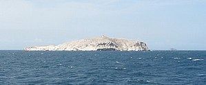
The Los Monjes islands, a federal dependency of Venezuela, are located to the northwest of the Gulf of Venezuela, 34.8 kilometres (21.6 miles) off the coast of Guajira Peninsula, at the border between Colombia and the Venezuelan state of Zulia.
Contents
- Archipi lago los monjes venezuela los monjes archipelago venezuela arquip lago de los monjes
- Map of Islas Los Monjes Venezuela
- References
Map of Islas Los Monjes, Venezuela
The islands consist of rocks rising steeply out of the sea, without any beaches or natural landing. The Venezuelan Navy maintains a base on El Sur, where it constructed a pier. The islands have no natural resources and must be supplied from the mainland. Fishing is the main activity around the islands, usually by fishing boats making the short trip from the Paraguaná Peninsula in Venezuela.
There are three islands or island groups, with a total area of 0.2 km2 (0.1 sq mi):
References
Los Monjes Archipelago Wikipedia(Text) CC BY-SA