
 | ||
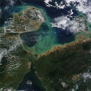
The Gulf of Venezuela is a gulf of the Caribbean Sea bounded by the Venezuelan states of Zulia and Falcón and by Guajira Department, Colombia. A 54 km (34 mi) strait connects it with Maracaibo Lake to the south.
Contents
Map of Gulf of Venezuela, Venezuela
Location
The Gulf is located in the north of South America, between Paraguaná Peninsula of the Falcón State in Venezuela and Guajira Peninsula in Colombia and is connected to Maracaibo Lake through an artificial navigation canal. There is currently a dispute between Colombia and Venezuela over the gulf that has not been resolved, despite the decades-long negotiations conducted by a bilateral commission.
History
It was discovered by westerners in 1499 when an expedition commanded by Alonso de Ojeda in which he was accompanied by Amerigo Vespucci, explored the Venezuelan coasts compiling information and naming the new lands, said expedition arrived to the gulf after passing through the Netherlands Antilles and the Peninsula of Paraguaná.
Territorial waters are also in dispute over the gulf. The border dispute surged after the independence of Colombia and Venezuela from Spain in the 19th Century. The Spanish empire did not delimit the area because the Wayuu indigenous group posed resistance in the area. The land boundary was finally settled in 1941, but not the maritime.
Economic importance
The main factor that gives importance to these waters is the fact that it connects the Caribbean Sea and Lake Maracaibo, an important source of crude petroleum for Venezuela. The gulf therefore helps connect the wells and refineries in Lake Maracaibo to the world markets.