
Admin. region Stuttgart Elevation 288 m (945 ft) Area 34.28 km² Postal code 73547 Dialling code 07172 | Time zone CET/CEST (UTC+1/+2) Population 11,149 (31 Dec 2008) Local time Monday 2:00 AM Administrative region Stuttgart | |
 | ||
Weather 3°C, Wind E at 13 km/h, 69% Humidity | ||
Lorch is a small town situated in the Ostalbkreis district, in Baden-Württemberg, Germany. It is situated on the river Rems, 8 km west of Schwäbisch Gmünd.
Contents
- Map of 73547 Lorch Germany
- Geography
- History
- Middle Ages
- Modern Times
- Period of National Socialism
- Born in Lorch
- References
Map of 73547 Lorch, Germany
Geography
Lorch is situated on the bank of the Rems, which is a tributary of the Neckar River, between Schwäbisch Gmünd to its east and Schorndorf to its west. North of Lorch is the Swabian-Franconian Forest and to the south lies the Swabian Alps. Lorch is a member of the Swabian-Franconian Forest Nature Park and is located at the Limes hiking route (HW 6) of the Swabian Alp Association. Lorch merged with the formerly-independent municipality of Waldhausen. Since December 31, 1971 it has included 35 different hamlets, villages and farms. As of 2012, Lorch has been divided into 5 boroughs: Kirneck (396 inhabitants), Lorch (6492 inhabitants), Rattenharz (251 inhabitants), Waldhausen (2698 inhabitants) and Weitmars (1030 inhabitants).
History
During the Roman Era, it served as a vital link in the Limes Germanicus. The monastery at Lorch was founded by Frederick I of Swabia in 1102.
Friedrich Schiller lived here as a child between 1764 and 1766.
The Roman Empire moved under Emperor Augustus shortly before the Christian era (15 v. Chr.) Its sphere to the north of the Alps in the premises of today's Switzerland, southern Germany and Austria. First, the upper Danube and the Upper Rhine formed the frontier. About 100 years later, the Romans appropriated the so-called by them Dekumatenland and thus the area of Lorch. The two provinces Raetia (Rhaetia) and Germania Superior (Upper Germany) have been established. The new external border of the empire was moved to the north and east and marks. Over the decades, this new limit was backed becoming stronger. The Upper Germanic-Rhaetian Limes originated. It said buckling between today's cities Lorch and Schwabisch Gmund met the eastern border of Upper Germany and the northern border of Raetia, which were also the external border of the Roman Empire, in a Limes knees together. The fort Lorch was under Emperor Antoninus Pius (reign 138-161 n. Chr.) As a cohort fort established to secure the Limes. It was the southernmost fort the Upper Germanic Limes; east concurred with the Rhaetian Limes. The center of the fort was in the yard of today's Protestant town church, the sides of the fort were approximately 150 to 160 meters long. The fort was joined by a civilian settlement ( vicus ), which is about a kilometer away along the run through the Remstal Roman highway developed. The time strategically important road leading from Augsburg ( Augusta Vindelicorum ) on today's Stuttgart-Bad Cannstatt to Mainz ( Mogontiacum ). The name Lorchs the Roman period is not secured; often Lauriacum is believed due to the medieval name and by analogy with the today also Lorch hot forming Lauriacum in Upper Austria. Between 260 and 268 the Romans gave under pressure from the Alemanni the northwestern part of Raetia and the eastern part of Upper Germany, thus reaching the limit and the fort Lorch on ( Limes case ); The Romans retreated to the west behind the Rhine, to the south behind the Lake Constance and the Upper Rhine and eastwards behind the Iller back ( Donau-Iller-Rhine-Limes ). Germans, the Romans called Alemanni, moved to and settled in the cleared by the Romans area down.
Middle Ages
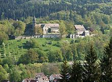
Reburial of Frederick I in the monastery (wall painting by Hans Kloss ) The early medieval history is in the dark; it is unclear whether the site has been inhabited continuously. In the mid-11th century a was Kollegiatstift to the city, in the village parish church founded. It was the tomb of the ancestors of the Staufer . Around 1100, the Staufer donated the monastery Lorch, a Benedictine, as their home monastery on the mountain, where unsecured according to tradition was a castle. The monastery certain from now on the fortunes of the town. Conrad III. Had his in the parish church buried ancestors umbetten in the monastery. Lorch was performed in the 12th century in various documents under the name Loricha and Lorche, in Latin as Laureacus and Laureacum monasterium. The monastery was in the 13th century under the bailiwick of the Counts of Württemberg . The pin on the parish was abolished in the second half of the 14th century. The village had in the late Middle Ages, the market law . At central facilities existed a court and a bathhouse .
Modern Times
Duke Ulrich was 1535 Reformation introduce in Lorch. In the wake of the Schmalkaldic War 1548 Catholic worship forms were first reintroduced, but from 1553 Protestant pastors were reinstated. Another result of the Reformation was the introduction of a school, for 1560 a special building was built. As Monastery of the duchy Württemberg was Lorch monastery in the 16th century abolished. The Thirty Years' War, the population Lorchs decreased to one third. In the following decades, began a lively reconstruction. 1660 could Lorch the lost before the war right recover two Fairs hold. From 1810 to 1819 was the seat of a Lorch Oberamt which thereafter to Welzheim was postponed. 1831 and 1832 Lorch received permissions for another two markets.
View from Monastery, circa 1895 With the opening of the section Bad Cannstatt-Wasseralfingen the Rems Railway 1861 Tourism gained economic importance; Accommodation options were off and rebuilt. On June 22, 1865 rose King Karl Lorch to the city. In addition to the City Council a Verschönerungsverein promoted tourism, and Lorch turned out to be the health resort on. For 1898 464 spa visitors were recorded, including 64 foreigners. In parallel, industrial enterprises were founded. Established in 1876 Gebrüder pasta factory Daiber had in 1904 125 employees and was thus the most important local employer. It was 1893 and the first users of electricity on site. The itself generated current was passed also to private homes in the village.
Period of National Socialism
In the elections at the beginning of the 1930s, the Nazi Party in Lorch and Waldhausen was well above the average.In the background was the high rate of unemployment. In January 1932, 340 people of Lorch were without a job. On the other hand was among the eight founding members of the local NSDAP from 1932 not a single employee. Ortsgruppenleiter was the stamp dealer Hermann E. Sieger.