
Time zone CET (UTC+1) Arrondissements 3 Area 4,781 km² Population 756,715 (2013) | Subprefectures MontbrisonRoanne Department number 42 Cantons 21 | |
 | ||
Colleges and Universities Jean Monnet University Destinations Points of interest Bourg‑Argental, Pélussin, Noirétable, Espace zoologique de Saint, Musée gallo‑romain de Saint | ||
Loire ([lwaʁ]; Arpitan: Lêre; Occitan: Léger) is a department in the east-central part of France occupying the River Loire's upper reaches.
Contents
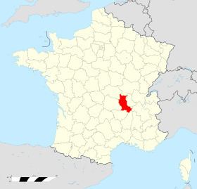
Map of Loire, France
History
Loire was created in 1793 when after just 3½ years the young Rhône-et-Loire department was split into two. This was a response to counter-Revolutionary activities in Lyon which, by population, was the country's second largest city. By splitting Rhône-et-Loire the government sought to protect the French Revolution from the potential power and influence of counter revolutionary activity in the Lyon region.
The departmental capitals have been / are as follows:
Geography
Loire is part of the current administrative region of Auvergne-Rhône-Alpes and is surrounded by the departments of Rhône, Isère, Ardèche, Haute-Loire, Puy-de-Dôme, Allier, and Saône-et-Loire.
The River Loire traverses the department from south to north.
The Loire department is split into three arrondissements :
Parts of the department belong to Parc naturel régional Livradois-Forez.
Demographics
The inhabitants of the department are called Ligériens.
The industrial city of Saint-Étienne with its suburbs contains some 290,000 of the area's 728,542 inhabitants.