
Website [1] Population 3,050 (2010) Area code 608 | Time zone Central (CST) (UTC-6) Area 4.58 km² Local time Saturday 8:56 PM | |
 | ||
Weather -6°C, Wind NW at 13 km/h, 31% Humidity | ||
Lodi /ˈloʊ.daɪ/ LOH-dye is a city in Columbia County, Wisconsin, United States. The population was 3,050 at the 2010 census. Lodi is part of the Madison Metropolitan Statistical Area.
Contents
- Map of Lodi WI 53555 USA
- History
- Historic places
- Geography
- 2010 census
- 2000 census
- Susie the Duck
- Lodi Agricultural Fair
- Ice Age Trail
- Notable residents
- Railroad
- References
Map of Lodi, WI 53555, USA
History
Isaac Palmer founded the village of Lodi in 1846 in what was then the Pleasant Valley Precinct of the Wisconsin Territory. He named it after Lodi, in Italy. Palmer chose this glaciated valley as the location for the village because of its water power potential. Spring Creek powered a sawmill that year and a grist mill followed in 1850.
Historic places
Geography
Lodi is located at 43°18′51″N 89°31′51″W (43.314296, −89.530994).
According to the United States Census Bureau, the city has a total area of 1.77 square miles (4.58 km2), all of it land.
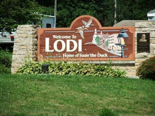
Spring Creek, which runs from the Lodi marsh through downtown Lodi and empties into Lake Wisconsin, is a local spring-fed brown trout stream. Portions of the creek do not freeze over the winter and thus serve as host to brown trout and waterfowl, particularly mallards. Lodi has adopted a Spring Creek resident mallard, which the residents have named "Susie the Duck", as a mascot.
2010 census
As of the census of 2010, there were 3,050 people, 1,224 households, and 796 families residing in the city. The population density was 1,723.2 inhabitants per square mile (665.3/km2). There were 1,272 housing units at an average density of 718.6 per square mile (277.5/km2). The racial makeup of the city was 96.3% White, 0.3% African American, 0.5% Native American, 1.0% Asian, 0.1% Pacific Islander, 0.8% from other races, and 1.0% from two or more races. Hispanic or Latino of any race were 2.0% of the population.
There were 1,224 households of which 34.0% had children under the age of 18 living with them, 49.3% were married couples living together, 10.8% had a female householder with no husband present, 5.0% had a male householder with no wife present, and 35.0% were non-families. 30.2% of all households were made up of individuals and 13.6% had someone living alone who was 65 years of age or older. The average household size was 2.44 and the average family size was 3.04.
The median age in the city was 40.4 years. 26.4% of residents were under the age of 18; 6.6% were between the ages of 18 and 24; 24.3% were from 25 to 44; 27.2% were from 45 to 64; and 15.5% were 65 years of age or older. The gender makeup of the city was 48.9% male and 51.1% female.
2000 census
As of the census of 2000, there were 2,882 people, 1,141 households, and 745 families residing in the city. The population density was 2,008.6 people per square mile (778.1/km²). There were 1,199 housing units at an average density of 835.7 per square mile (323.7/km²). The racial makeup of the city was 98.27% White, 0.17% Black or African American, 0.28% Native American, 0.24% Asian, 0.03% Pacific Islander, 0.31% from other races, and 0.69% from two or more races. 1.01% of the population were Hispanic or Latino of any race.
There were 1,141 households out of which 35.1% had children under the age of 18 living with them, 53.3% were married couples living together, 8.7% had a female householder with no husband present, and 34.7% were non-families. 28.8% of all households were made up of individuals and 14.2% had someone living alone who was 65 years of age or older. The average household size was 2.44 and the average family size was 3.03.
In the city, the population was spread out with 26.6% under the age of 18, 5.8% from 18 to 24, 31.9% from 25 to 44, 20.2% from 45 to 64, and 15.4% who were 65 years of age or older. The median age was 36 years. For every 100 females there were 90.2 males. For every 100 females age 18 and over, there were 88.0 males.
The median income for a household in the city was $51,357, and the median income for a family was $57,763. Males had a median income of $37,049 versus $27,063 for females. The per capita income for the city was $23,546. About 1.6% of families and 2.7% of the population were below the poverty line, including 1.4% of those under age 18 and 9.5% of those age 65 or over.
Susie the Duck
Susie the Duck has been the town's official mascot since 1948. On Wisconsin Highway 113 in downtown Lodi is a small creek-side park where visitors can buy dried corn from vending machines to feed the wild ducks. In this area is a small stone basket, inscribed with the name of former Lodi resident Engle Knerzer, and every year a duck builds a nest there. When the first mallard settled in that location in 1948, it was nicknamed "Susie" by the granddaughter of the police chief.
There is an annual "Susie the Duck Day" celebration, the highlight of which is the rubber duck race. Participants pay a fee for a small rubber duck. The thousands of ducks are then dumped into the creek where they "race" toward a finish line and prizes are awarded based on order of finish. The day's celebrations also include a parade, activities in Goeres Park, brat stands on Main Street and in Goeres Park, and a beer garden in the park.
Lodi Agricultural Fair
Lodi is one of three cities in Wisconsin to have its own fair. This free fair begins on the first Thursday of July and runs through Sunday. Exhibits include livestock judging, school artwork, baking contests, and local organization display booths. There are carnival rides and games. Attractions include tractor pulls, a demolition derby, a live music beer garden, and a high school alumni softball tournament. In 2015, the Lodi Agricultural Fair marked its 150th anniversary, which was celebrated by adding an additional day onto the event.
Ice Age Trail
A portion of the Ice Age National Scenic Trail runs through Lodi. Lodi's chapter of the Ice Age Park and Trail Foundation maintains an office in downtown Lodi, with access to the trail several hundred yards away. The longest section of the trail in the area is about 6.2 miles. It begins at the Robertson Trailhead, south of Lodi on Lodi-Springfield Road off of Hwy. 60 West. Several other segments of the trail are located in or near Lodi, including a 1.3-mile segment on the corner of Lovering and Highway J and a 21-mile section north of the Colsac III Ferry on Lake Wisconsin.
Notable residents
Railroad
Wisconsin and Southern runs through town en route to Reedsburg, WI.