
Primary inflows Max. depth 40 ft (12 m) Surface elevation 236 m | Surface area 9,500 acres (3,800 ha) Area 38.45 km² Outflow location Wisconsin River Lake type Reservoir | |
 | ||
Similar Devil's Lake State Park, Lake Delton, Devil's Lake, Lake Winnebago, Merrimac Ferry | ||
Lake Wisconsin is a reservoir on the Wisconsin River in southern Wisconsin in the United States. It is located in Columbia and Sauk counties, approximately 5 mi (8 km) southeast of Baraboo and 25 mi (40 km) NNW of Madison. Today it is home to the Wisconsin wine appellation of the Lake Wisconsin AVA.
Map of Lake Wisconsin, Wisconsin, USA
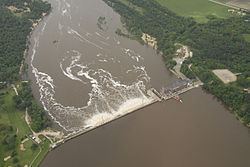
It was formed by the construction of a dam at Prairie du Sac, which was begun in 1911 and completed in 1914. It is part of the Wisconsin River system of reservoirs. The lake has a maximum depth of 40 ft (12 m). It has a shoreline of 57 mi (90 km) and an area of 9500 acres (38 km²).
Its construction effectively ended the Fox-Wisconsin Waterway connection to the Mississippi River, although commercial traffic had ended decades before completion of the dam.
The lake provides flood control and is a popular destination for recreational boating and fishing.
The Merrimac Ferry crosses the lake at Merrimac, Wisconsin.