
Type natural Basin countries United Kingdom | Surface elevation 605 m | |
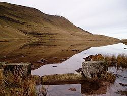 | ||
Llyn y Fan Fawr (Welsh: 'lake of the big peak') is a natural lake in the county of Powys, Wales. It lies at the foot of Fan Brycheiniog, the highest peak of the Black Mountain (WelshY Mynydd Du) range within the Brecon Beacons National Park. The lake is one of the largest glacial lakes in southern Wales and is roughly rectangular in shape with its long axis oriented roughly north-south.
Contents
Map of Llyn y Fan Fawr, Swansea, UK
GeologyEdit
The lake is overlooked by several prominent mountain peaks, especially Fan Hir, Fan Brycheiniog and Fan Foel. Both peaks are formed from the sandstones and mudstones of the Brownstones Formation of the Old Red Sandstone laid down during the Devonian period. Its southern slopes are formed from the hard-wearing sandstones of the overlying Plateau Beds Formation which are of upper/late Devonian age. It is those rocks which form vertical cliffs along the top edge of the scarp.
DrainageEdit
The lake is enclosed within a rock hollow formed as a result of glacial action during the ice ages. It is drained by a stream known as Nant y Llyn (Welsh: 'stream of the lake'), whose waters flow into the River Tawe. The surface of Llyn y Fan Fawr lies at about 1815 feet or 605m above sea level. Much of the land around the lake is peaty and thus wet underfoot.
Llyn y Fan Fach (Welsh: 'lake of the small peak') which lies about 2 miles (or 3 km) to the west is of similar origin and slightly smaller in size; it lies about 100m lower. It was dammed with a small increase in height of the lake in the 1930s to improve the water supply for Llanelly.
AccessEdit
The lake can be reached on foot by a 2 mile walk (or about 3 km) across the peat moorland from the minor Trecastle to Abercraf road, where there is a small parking place. There is another small car park about 500 yards away to the south, which also marks the start of a footpath to the lake. The upper path crosses many small streams as well as peat bogs and needs some skill at navigation, especially where the path rises gently to the lake itself. The footpath meets the Beacons Way path just by the south end of the lake, from where it climbs the escarpment via a well graded stone slab staircase to Fan Brycheiniog and then Fan Foel on the leading edge of the cliffs. The views of the lake from the path are impressive, revealing its size in the landscape. All of the surrounding moorland is of open access but is often wet and rough underfoot. The footpath offers fast and safe progress, although it is not always easy to find below the lake.
The lake can also be reached from the ridge of Fan Hir to the east. The path follows the edge of the escarpment, and there are spectacular views of Mynydd Epynt and the Cambrian mountains to the north. The path leads to the stone staircase which drops down to the lake itself.
WildlifeEdit
There are numerous different species of bird in the area, and they include the red kite, common buzzard, kestrel, carrion crow, common raven and skylark to name a few of the most obvious residents. The kestrel and buzzard are widely distributed, but the raven is restricted to the higher mountains. There is a wide distribution of mammals such as field voles, foxes and badgers as well as many songbirds. The skylark is plentiful due to the extensive rough pasture present below the main peaks which allows ground nesting of the species. Pied wagtails are common near the streams and torrents running from the hill tops.