
Counties: Vanderburgh Constructed 19 July 1988 | Length 23 km | |
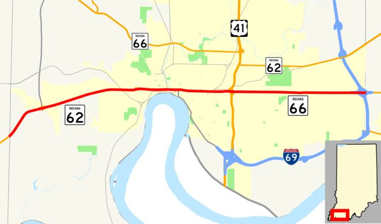 | ||
Existed: July 19, 1988 (1988-07-19) – present Componenthighways: SR 62 west of US 41 SR 66 east of US 41 County | ||
U s highway 41 lloyd expressway grand unveiling sept 9 2015
The Lloyd Expressway is a major east–west traffic artery located in Vanderburgh County, Indiana. The route primarily runs through Evansville, Indiana, although the route designation continues west of the Evansville city limits into Perry Township. West of US 41, the expressway is signed as Indiana State Road 62 (SR 62); east of US 41, it is signed as Indiana State Road 66 (SR 66). (North of the expressway, both SR 62 and SR 66 run concurrently with US 41. SR 62 later turns east as Morgan Avenue; shortly after that, SR 66 turns west as Diamond Avenue.)
Contents
- U s highway 41 lloyd expressway grand unveiling sept 9 2015
- Luke recording driving lloyd expressway evansville may 2 2015
- Route description
- History
- Major intersections
- References
Luke recording driving lloyd expressway evansville may 2 2015
Route description
The expressway contains a mix of intersections and interchanges. Although Evansville residents are said to use the term “expressway” loosely, often using the term "The Lloyd" instead, due to the large number of intersections along the city's stretch of the route, the road actually has many of the characteristics in the standard definition of "expressway": Opposing traffic is separated between intersections and interchanges, largely by medians. There are few driveways along the expressway, with most access made via side roads; most of the driveways that do intersect with the expressway allow right-in/right-out access only, without direct access to or from the opposing lanes.
The expressway either runs adjacent to or supplants Division Street, and serves mainly as a one-way or two-way frontage road east to nearly the Warrick County line.
The expressway is named in honor of former mayor Russell G. Lloyd, Sr., who was assassinated after leaving office in 1980.
History
Prior to the expressway, Division Street existed only east of Main Street where, for a short stretch, a railroad ran in tandem down the center of the street (it was decommissioned and removed since the construction of the expressway). Areas west of Main Street along where Division Street would have extended was known as Pennsylvania Avenue. West of Barker Avenue, for about 1.5 miles to the edge of the city limits, the stretch of SR 62 was formerly known as Pennsylvania Avenue even as the highway was drifting south of the city (and county) division line. Congestion on the Pennsylvania Avenue/Division Street artery necessitated an expressway.
The road was built in various stages. The west section of the expressway was completed in the 1950s with plans to continue it east at a later date as funding became available. In the spring of 1983, demolition began on buildings in the expressway's path, with road construction starting on July 29, 1983. Motorists endured five years of detours and construction as the expressway was built through the heart of the city. This phase cost $160 million and officially opened on July 19, 1988. Although there are many traffic signals and there are problems with flooding, the current configuration of the expressway has allowed drivers to travel from one end of the city to the other much more easily than before.
Major intersections
The entire expressway is in Vanderburgh County.