
Website www.poseycountyin.gov Founded 1814 Unemployment rate 3.7% (Apr 2015) | Area 1,086 km² Population 25,486 (2013) | |
 | ||
Rivers Wabash River, Big Creek, Black River, Big Bayou | ||
145 acres offered in three tracts ribeyre island posey county indiana
Posey County is a county located in the southwestern corner of the U.S. state of Indiana. As of 2010, the population was 25,910. The county seat is Mount Vernon.
Contents
- 145 acres offered in three tracts ribeyre island posey county indiana
- Map of Posey County IN USA
- History
- Geography
- Adjacent counties
- Cities and towns
- Census designated place
- Major highways
- Railroads
- River Ports
- Climate and weather
- Government
- Demographics
- Education
- Tourism Recreation
- References
Map of Posey County, IN, USA
Posey County is part of the Evansville, IN–KY Metropolitan Statistical Area.
History
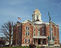
Posey County was formed on November 11, 1814 from Gibson and Warrick counties. It was named for Revolutionary War Gen. Thomas Posey, who was then serving as Governor of the Indiana Territory. Mount Vernon became the county seat in 1825.
Geography
According to the 2010 census, the county has a total area of 419.32 square miles (1,086.0 km2), of which 409.57 square miles (1,060.8 km2) (or 97.67%) is land and 9.75 square miles (25.3 km2) (or 2.33%) is water. The lowest point in the state of Indiana is located on the Ohio River in Posey County, where the waters of the Wabash River join it and flow out of Indiana and into Illinois and Kentucky.
Adjacent counties
Cities and towns
Census-designated place
Major highways
Railroads
River Ports
Climate and weather
In recent years, average temperatures in Mount Vernon have ranged from a low of 23 °F (−5 °C) in January to a high of 87 °F (31 °C) in July, although a record low of −21 °F (−29 °C) was recorded in January 1912 and a record high of 109 °F (43 °C) was recorded in July 1901. Average monthly precipitation ranged from 2.65 inches (67 mm) in September to 5.38 inches (137 mm) in May.
Government
The county government is a constitutional body, and is granted specific powers by the Constitution of Indiana, and by the Indiana Code.
County Council: The county council is the legislative branch of the county government and controls all the spending and revenue collection in the county. Representatives are elected from county districts. The council members serve four-year terms. They are responsible for setting salaries, the annual budget, and special spending. The council also has limited authority to impose local taxes, in the form of an income and property tax that is subject to state level approval, excise taxes, and service taxes.
Board of Commissioners: The executive body of the county is made of a board of commissioners. The commissioners are elected county-wide, in staggered terms, and each serves a four-year term. One of the commissioners, typically the most senior, serves as president. The commissioners are charged with executing the acts legislated by the council, collecting revenue, and managing the day-to-day functions of the county government.
Court: The county maintains a small claims court that can handle some civil cases. The judge on the court is elected to a term of four years and must be a member of the Indiana Bar Association. The judge is assisted by a constable who is also elected to a four-year term. In some cases, court decisions can be appealed to the state level circuit court.
County Officials: The county has several other elected offices, including sheriff, coroner, auditor, treasurer, recorder, surveyor, and circuit court clerk Each of these elected officers serves a term of four years and oversees a different part of county government. Members elected to county government positions are required to declare party affiliations and to be residents of the county.
Demographics
As of the 2010 United States Census, there were 25,910 people, 10,171 households, and 7,442 families residing in the county. The population density was 63.3 inhabitants per square mile (24.4/km2). There were 11,207 housing units at an average density of 27.4 per square mile (10.6/km2). The racial makeup of the county was 97.2% white, 0.9% black or African American, 0.3% Asian, 0.2% American Indian, 0.4% from other races, and 1.1% from two or more races. Those of Hispanic or Latino origin made up 1.0% of the population. In terms of ancestry, 43.6% were German, 13.6% were American, 11.6% were Irish, and 11.2% were English.
Of the 10,171 households, 32.7% had children under the age of 18 living with them, 60.4% were married couples living together, 8.5% had a female householder with no husband present, 26.8% were non-families, and 23.3% of all households were made up of individuals. The average household size was 2.52 and the average family size was 2.97. The median age was 41.6 years.
The median income for a household in the county was $47,697 and the median income for a family was $68,722. Males had a median income of $55,786 versus $32,747 for females. The per capita income for the county was $26,727. About 6.0% of families and 8.3% of the population were below the poverty line, including 12.2% of those under age 18 and 8.3% of those age 65 or over.