
Elevation 2,886 m | ||
 | ||
Mountain type serpentiniterock summit Similar Geier, Lizumer Sonnenspitze, Rosenjoch, Mölsberg, Kalkwand | ||
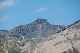
The Lizumer Reckner is, at 2,886 m (AA), the highest mountain in the Tux Alps in the Austrian state of Tyrol.
Contents
Map of Lizumer Reckner, 6294, Austria
Location and areaEdit
The Lizumer Reckner lies in the centre of the Tux Alps, about 20 kilometres southeast of Innsbruck within the Lizum Walchen Training Area (Truppenübungsplatz Lizum Walchen). To the west lies the Navis valley, to the southeast the Schmirn valley and to the east the Wattener Lizum. The Tuxertal valley lies not far to the southeast. It neighbouring mountain to the south is the Geier. To the north a mountain crest runs to the Lizumer Sonnenspitze, the Tarntaler Köpfe and eventually as far as the Mölsberg. To the west of the Lizumer Reckner is the 2,824 m high Naviser Reckner (47°08′39″N 11°37′27″E).
GeologyEdit
The Reckner lies on the edge of the Tauern window, a region of the Eastern Alps, in which Penninic nappes and possibly also Helvetic nappes are exposed. The summit block of the Reckner consists of serpentinite, which is mainly embedded in radiolarite. Furthermore, in the geologically diverse surrounding area dolomite breccias, kalkschiefer and other rocks of the Jurassic period.
Below the summit block of the Reckner there are stone runs, that are seen as the remains of a former rock glacier. Traces of dead ice may also be found here.
Bases and trailsEdit
From the Navis valley (Navistal) the mountain may be climbed inter alia from the Naviser Hut (1,767 m) or the Peeralm (1,663 m). In the Schmirn valley (Schmirntal) the hamlet of Obern acts as a departure point. From the Tuxertal the Reckner can be ascended from the 1,984 m high Junsbergalm or from Hintertux. The most important base in the Wattener Lizum is the Lizumer Hut (2,019 m).
The southern foot of the summit block can be reached from all these bases over a number of marked hiking trails. The climb from the Lizum is also possible in winter as a ski tour. The final climb to the summit requires some easy climbing and is partly secured as a Klettersteig.
Due to its location within the military training area, ascents of the mountain are banned from time to time.