
Peak Cima de' Piazzi Elevation 3,439 m Province Province of Sondrio | Highest point Cima Piazzi Country Italy | |
 | ||
States Graubünden and Lombardy Mountains Similar Alps, Oberhalbstein Alps, Albula Alps, Plessur Alps, Sesvenna Alps | ||
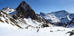
The Livigno Alps are a mountain range in the Alps of eastern Switzerland and northern Italy, around the Italian village Livigno. They are considered to be part of the Central Eastern Alps.
Contents
Map of Livigno Alps, 23030 Livigno, Province of Sondrio, Italy
The Livigno Alps are separated from the Bernina Range in the south-west by the Bernina Pass; from the Albula Alps in the north-west by the Upper Engadin valley; from the Sesvenna Range in the north-east by the Ofen Pass and Val Müstair; from the Ortler Alps in the east by the upper Adda River valley (Valtellina) and the Stelvio Pass.
The Livigno Alps are drained by the rivers Adda River, Inn and Rom (tributary of the Adige).
PeaksEdit
The main peaks of the Livigno Alps are:
PassesEdit
The main passes of the Livigno Alps are:
References
Livigno Alps Wikipedia(Text) CC BY-SA