
Elevation 3,905 m Province South Tyrol Parent range Southern Limestone Alps | Country Italy | |
 | ||
Borders on Livigno Range and Adamello-Presanella Mountains Ortler, Gran Zebrù, Hasenöhrl, Monte Zebrù, Palon de la Mare Similar Monte Cevedale, Alps, Gran Zebrù, Adamello‑Presanella Alps, Presanella | ||
Speed ride world record attempt preparation at sulden ortler alps official teaser video
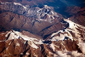
The Ortler Alps (Italian: Ortles-Cevedale [ˌɔrtlestʃeveˈdaːle]; German: Ortler-Alpen) are a mountain range of the Southern Limestone Alps mountain group in the Central Eastern Alps, in Italy and Switzerland.
Contents
- Speed ride world record attempt preparation at sulden ortler alps official teaser video
- Map of Ortler Alps 39020 Martell Province of Bolzano South Tyrol Italy
- Ski mountaineering trip in ortler alps
- GeographyEdit
- PeaksEdit
- Mountain passesEdit
- HistoryEdit
- References
Map of Ortler Alps, 39020 Martell, Province of Bolzano - South Tyrol, Italy
Ski mountaineering trip in ortler alps
GeographyEdit
The Ortler Alps are separated from:
- the Livigno Range in the north-west by the Stelvio Pass and the Adda River valley (Valtellina)
- the Adamello-Presanella range in the south by the Tonale Pass
- the Ötztal Alps in the north-east by the upper Adige valley (Vinschgau).
The part west of the Gavia Pass is also called Sobretta-Gavia Group.
The Ortler Alps are drained by the rivers Adda, Oglio, Adige and its tributary Noce.
PeaksEdit
The main peaks of the Ortler Alps are:
Mountain passesEdit
The main mountain passes of the Ortler Alps are:
HistoryEdit
The Ortler Alps were part of the Italian front during World War I. In this area, the Austro-Hungarians and the Italians dug in in a trench war fought at altitudes above 3,000 m (10,000 ft) for most of the war. Some trenches are still visible today, and war relics continue to be found in the area.