
Isolation 200 km (124.4 mi) Easiest route glacier/snow/ice climb First ascent 8 June 1931 | Topo map NTS 114I/13 Elevation 4,671 m Prominence 3,956 m | |
 | ||
Listing World most prominent peaks 26thNorth America highest peaks 18thNorth America prominent peaks 6thNorth America isolated peaks 106thCanada highest major peaks 8thUS highest major peaks 7th Similar Mount Hubbard, Mount Saint Elias, Mount Vancouver, Mount Alverstone, Mount Bona | ||
50 classics carpe ridge mount fairweather 2013
Mount Fairweather (officially gazetted as Fairweather Mountain in Canada but referred to as Mount Fairweather), is one of the world's highest coastal mountains at 4,671 metres (15,325 feet.) It is located 20 km (12 mi) east of the Pacific Ocean on the border of Alaska, United States and western British Columbia, Canada. Most of the mountain lies within Glacier Bay National Park and Preserve in the City and Borough of Yakutat, Alaska (USA), though the summit borders Tatshenshini-Alsek Provincial Park, British Columbia (Canada), making it the highest point in that province. It is also designated as Boundary Peak 164 or as US/Canada Boundary Point #164.
Contents
- 50 classics carpe ridge mount fairweather 2013
- Map of Mt Fairweather
- Geography
- Weather
- Climbing history
- References
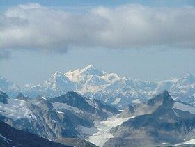
Map of Mt Fairweather
The mountain was named on May 3, 1778 by Captain James Cook, apparently for the unusually good weather encountered at the time. The name has been translated into many languages. It was called "Mt. Beautemps" by La Perouse (1786, atlas), "Mte. Buen-tiempo" by Galiano (1802, map 3), "Gor[a]-Khoroshy-pogody" on Russian Hydrographic Dept. Chart 1378 in 1847, and "G[ora] Fayerveder" by Captain Tebenkov (1852, map 7), Imperial Russian Navy. It was called "Schönwetterberg" by Constantin Grewingk in 1850 and "Schönwetter Berg" by Justus Perthes in 1882.
Fairweather was first climbed in 1931 by Allen Carpé and Terris Moore.
Geography
Mount Fairweather is located right above Glacier Bay in the Fairweather Range of the Saint Elias Mountains. Mount Fairweather also marks the northwest extremity of the Alaska Panhandle.
Like many peaks in the St. Elias Mountains, Mount Fairweather has great vertical relief due to its dramatic rise from Glacier Bay. However, due to poor weather in the area, this effect is usually obscured with the clouds which often hides the summit from view.
Known in the Tlingit language as Tsalxhaan, it is said this mountain and Yaas'éit'aa Shaa (Mt. St. Elias) were originally next to each other but had an argument and separated. Their children, the mountains in between the two peaks, are called Tsalxhaan Yatx'i (Children of Tsalxaan.)
Weather
Despite its name, Mount Fairweather has generally harsh weather conditions. It receives over 100 inches (254 cm) of precipitation each year (mostly snow) and sees temperatures of around -50 °F (-46 °C).