
- left Boutin River - elevation 0 m (0 ft) Discharge 280 m³/s Basin area 15,900 km² | - location Point Qilalugarsiuvik Length 380 km Basin area 15,900 km² Province Québec | |
 | ||
- average 280 m/s (9,890 cu ft/s) | ||
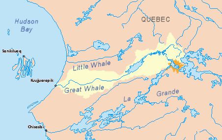
The Little Whale River (French: Petite rivière de la Baleine) (Cree: Wâpamekustûss) is a river in Nunavik, Quebec, Canada. With an area of 15,900 square kilometres (6,100 sq mi), it is ranked as the 35th largest river basin in Quebec.
Contents
Map of Petite rivi%C3%A8re de la Baleine, Baie-d'Hudson, QC, Canada
The Cree named a segment of the Little Whale River near its mouth as Wapimakustus, which is similar to what Isbister noted in 1740. The Inuit call it Qilalugarsiuviup Kuunga, which means "river or place where beluga is hunted".
Its name has often been wrongly translated into French as Rivière de la Petite Baleine.
History
In the records of 1740 kept by Joseph Isbister of the Eastmain Post, there is reference to a river called Wapameg-Us-Sosh (meaning White Whale River), where a multitude of beluga is found. It mentions that the river is located a short distance south of the Gulph [sic] (that is Richmond Gulf or Lac Guillaume-Delisle in French).
The English name of the river was first recorded in 1744 in the logbooks of Hudson's Bay Company employees Thomas Mitchell and John Longland, while exploring the bay's coast. On July 29, Mitchell made mention of Little White Whale River. For the 1750 mining attempt see Richmond Gulf.
From 1853 to 1890, the Hudson's Bay Company operated a trading post, named after the river, at its mouth. This place, now known as Jiaviniup Narsanga, has long been abandoned.