
Location Wicklow, Ireland Topo map OSi Discovery 56 Prominence 247 m Listing Marilyn | OSI/OSNI grid O260144 Elevation 342 m Province Leinster | |
 | ||
Similar Maulin, Carrickgollogan, Two Rock, Barnaslingan, Lobawn | ||
Hiking little sugar loaf and bray head co wicklow ireland
Little Sugar Loaf, also called Giltspur Mountain (Irish: Giolspar, earlier name Beannach Bheag), is a hill in County Wicklow, Ireland.
Contents
- Hiking little sugar loaf and bray head co wicklow ireland
- Map of Little Sugar Loaf Kilruddery Deerpark Co Wicklow Ireland
- Little sugar loaf wicklow 4 4 13
- Geography
- References
Map of Little Sugar Loaf, Kilruddery Deerpark, Co. Wicklow, Ireland
Little sugar loaf wicklow 4 4 13
Geography
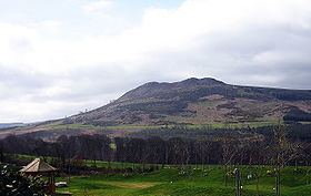
The mountain is situated East-North-East of the Great Sugar Loaf, separated from it by the N11 dual carriageway. The northern side of Little Sugar Loaf directly overlooks the town of Bray; the eastern side (see photo) looks across the R761 between Bray and Greystones to the western slope of Bray Head.
It is readily identifiable by its distinctive rocky double summit which contrasts with the hilltops in the area which, apart from Bray Head, are very regular in appearance. It is the 913th highest summit in Ireland.
References
Little Sugar Loaf Wikipedia(Text) CC BY-SA