
Prominence 216 m (709 ft) Topo map OSi Discovery 56 Province Leinster Listing Marilyn | OSI/OSNI grid O237130 Elevation 501 m | |
 | ||
Similar Wicklow Mountains, Little Sugar Loaf, Powerscourt Estate, Bray Head, Powerscourt Waterfall | ||
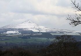
The Great Sugar Loaf (Irish: Ó Cualann or Beannach Mhór), also known as the Big Sugar Loaf and often as simply the Sugar Loaf, is a mountain in east County Wicklow in Ireland.
Contents
Map of Great Sugar Loaf, Glencap Commons South, Co. Wicklow, Ireland
Geography
The mountain is located between Delgany and Kilmacanogue, and just to the north of the Glen of the Downs Nature Reserve. The smaller Little Sugar Loaf lies to the east (on the other side of the N11 road).
Though only 501 metres (1,644 ft) high, the Great Sugar Loaf's isolation from other hills, steep slopes and volcanic appearance makes it stand out in the landscape. Due to its height relative to the surrounding landscape, the hill qualifies as a Marilyn.
Geology
The Great Sugar Loaf is composed of Cambrian quartzite, in contrast to the rounded mountains to the west, which are made of Devonian granite. Popularly mistaken for a volcano, it is in fact an erosion-resistant metamorphosed sedimentary deposit from the deep sea.