
- elevation 1,467 ft (447 m) - average 72.5 cu ft/s (2 m/s) Length 133 km Source Amboy Township | - elevation 787 ft (240 m) Discharge 2.053 m³/s Basin area 595.7 km² | |
 | ||
- max 3,520 cu ft/s (100 m/s) Bridges Marsh Concrete Rainbow Arch Bridge Mouths Minnesota River, Cambria Township | ||
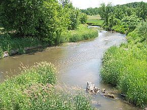
Little cottonwood river ledges rapids
The Little Cottonwood River is a tributary of the Minnesota River, 83 miles (133 km) long, in southwestern Minnesota in the United States. Via the Minnesota River, it is part of the watershed of the Mississippi River, draining an area of 230 square miles (596 km²) in an agricultural region.
Contents
- Little cottonwood river ledges rapids
- Map of Little Cottonwood River Minnesota USA
- Flow rateEdit
- References
Map of Little Cottonwood River, Minnesota, USA
The Little Cottonwood River rises south of Jeffers in Amboy Township in Cottonwood County, beginning as a drainage ditch constructed in 1997. In its upper course the stream flows swiftly in a northeastward course and passes rock outcrops, including the Jeffers Petroglyphs. It flows generally east-northeastwardly through Brown County into northwestern Blue Earth County, where it joins the Minnesota River in Cambria Township, approximately seven miles (11 km) southeast of New Ulm. For much of its lower course, it roughly parallels the Cottonwood River to the north at a distance of three to ten miles (5–15 km). The stream's watershed is narrow, with no major tributaries. Land within the watershed consists primarily of till plains; in 1990, 90% of the land was cultivated for agriculture.
Common fish in the river include black and yellow bullhead, rock bass, golden redhorse, and various species of darters and shiners.
Flow rateEdit
At the United States Geological Survey's stream gauge in Cambria Township, 0.7 miles (1.1 km) upstream from the river's mouth, the annual mean flow of the river between 1974 and 2005 was 72.5 cubic feet per second (2 m³/s). The highest recorded flow during the period was 3,520 ft³/s (100 m³/s) on June 20, 1993. The lowest recorded flow was less than 0.1 ft³/s (0 m³/s) on September 17, 1977.