Samiksha Jaiswal (Editor)

List of mountains and hills of the Black Forest

Updated on
Edit
Like
Comment
Share on FacebookTweet on TwitterShare on LinkedInShare on Reddit
List of mountains and hills of the Black Forest

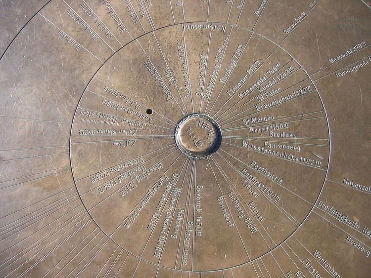
The list contains a selection of the mountains and hills in the Black Forest, in order of their height.

Contents

Over 1,400 m

  • Feldberg (1,493 m), highest mountain in the German Central Uplands
  • Baldenweger Buck (1,460 m), northern subpeak of the Feldberg
  • Seebuck (1,448 m), southeastern subpeak of the Feldberg
  • Herzogenhorn (1,415 m), south of the Feldberg
  • Belchen (1,414 m), southwest of the Feldberg
  • Over 1,300 m

  • Stübenwasen (1,386 m), between Feldberg and Notschrei
  • Grafenmatte (1,377 m), between Feldberg and Herzogenhorn
  • Immisberg (1,373 m), northwest of the Feldberg
  • Silberberg (1,358 m), between Todtnau-Brandenberg and Herzogenhorn
  • Spießhorn (1,349 m), between Bernau-Hof and Menzenschwand
  • Toter Mann (1,321 m), between Feldberg and Oberried
  • Bärhalde (1,317), between Neuglashütten and Menzenschwand
  • Köpfle (Feldberger Hof) (1,317 m), near the Feldberger Hof
  • Blößling (1,309 m), southwest of Bernau
  • Schweizerwald (1,305 m), 3 km north of the Seebuck
  • Over 1,200 m

  • Schnepfhalde (1,299 m), between Schluchsee and Menzenschwand
  • Schauinsland (1,284 m), local mountain of Freiburg im Breisgau
  • Trubelsmattkopf (1,281 m), between Notschrei, Muggenbrunn and Wiedener Eck
  • Heidstein (1,274 m), between Belchen and Wiedener Eck
  • Oberer Habsberg (1,274 m), west of the Schluchsee (often wrongly spelt Hubsberg; other tops at 1,263 m and 1,253 m)
  • Unterer Habsberg (1,204 m)
  • Kapellenkopf (1,273 m), between Schluchsee-Aha and Bernau-Hinterdorf
  • Wieswaldkopf (1,270 m), between Feldberg and Hinterzarten
  • Haldenköpfle (1,265 m), between Schauinsland and Notschrei
  • Hirschkopf (1,264 m), between St. Wilhelm and Notschrei
  • Hochfahrn (1,264 m), between Feldberg and Oberried
  • Hochkopf (1,263 m), between Neuglashütten and Feldberg by the Bundesstraße 317
  • Schweinekopf (1,257 m), west of the Blößling
  • Schmaleck (1,253 m), between St. Wilhelm and Feldberg
  • Ahornkopf (1,243 m), between Notschrei and St. Wilhelm
  • Gisiboden (1,243 m), between Todtnau and Bernau
  • Hohe Zinken (1,242 m), southwest of Bernau
  • Kandel (1,241 m), between St. Peter (High Black Forest) and the Elz valley
  • Köpfle (Todtnau) (1,235 m), northwest of Todtnau-Muggenbrunn
  • Köhlgarten (1,224 m), between Belchen and Blauen
  • Horneck (1,222 m), between Hinterzarten and Oberried
  • Farnberg (1,218 m), between Todtmoos-Rütte and St. Blasien
  • Bankgallihöhe (1,210 m), between Hinterzarten and Oberried
  • Bötzberg (1,209 m), between Schluchsee and St. Blasien
  • Windeck (1,209 m), southwest of Hinterzarten
  • Sengalenkopf (1,208 m), 2 km east of Todtnau-Gschwend
  • Hochgescheid (1,205 m), 3 km southeast of Schönau
  • Over 1,100 m

  • Hinterwaldkopf (1,198 m), between Oberried and Hinterzarten
  • Hochfirst (1,190 m), 3 km east of the Titisee
  • Weißtannenhöhe (1,190 m), 5 km north of the Titisee
  • Wiedener Hörnle (1,187 m), between Notschrei and Wiedener Eck
  • Obereck (1,177 m), 2 km southwest of the Rohrhardsberg (on the older maps the 1180 metre contour was shown)
  • Griesbacher Eck (1,172 m), near the Obereck
  • Dachsbühl (1,171 m), near the Erlenbach Hut
  • Rohrenkopf (1,170 m), north of Gersbach
  • Blauen (also Hochblauen; 1,165 m), southeast of Badenweiler
  • Hornisgrinde (1,164 m), (highest mountain of the Northern Black Forest)
  • Hasenhorn (1,156 m), 1 km southeast of Todtnau
  • Kaiserberg (1,156 m), by Riggenbach in the municipality of Bernau
  • Roteck (1,156 m), 1 km northwest of the Hinterwaldkopf
  • Roßeck (1,154 m), 7 km northwest of Furtwangen
  • Herrenschwander Kopf (1,152 m), 5 km southeast of Schönau
  • Rohrhardsberg (1,152 m), between Elzach and Furtwangen
  • Brend (1,149 m), 5 km northwest of Furtwangen
  • Ibichkopf (1,146 m), 3 km subpeak of the Obereck
  • Steinberg (1,141 m), 2 km northeast of Waldau
  • Staldenkopf (1,135 m), 1.5 km south of Todtnau-Gschwend
  • Bossenbühl (1,128 m), 2 km east of Waldau
  • Roßberg (1,125 m), 500 m north of Breitnau
  • Knöpflesbrunnen (1,124 m), 2 km west of Todtnau
  • Hornkopf (1,121 m), 2 km south of Simonswald
  • Hohwart (1,120 m), 2.5 km northwest of Breitnau
  • Notschrei (1,119 m), pass between Oberried and Todtnau
  • Eckle (1,114 m), between Hinterzarten and Feldberg-Bärental
  • Sirnitzkopf (1,114 m), 7 km east of Badenweiler
  • Over 1,000 m

  • Altsteigerskopf (1,092 m), 4 km southeast of the Hornisgrinde
  • Geißkopf (1,090 m), 3.5 km southeast of the Hornisgrinde
  • Tafelbühl (1,084 m), 3 km west of the Rohrhardsberg
  • Hundsrücken (1,080 m), northeast of the Hornisgrinde
  • Zeller Blauen (today more rarely the Hochblauen; 1,077 m), 3 km north of Zell i. W.
  • Schultiskopf (1,077 m), 3 km east of Altsimonswald
  • Sommerberg (1,076 m), 3 km southeast of Furtwangen
  • Hohspirn (1,074 m), between Falkau and Lenzkirch-Raitenbuch
  • Steiertenkopf (1,073 m), between Feldberg and Hinterzarten
  • Schattann (1,067 m), 2.5 km west of Bürchau
  • Stöcklewald (1,067 m), 5 km south of Triberg
  • Schwarzkopf (1,057 m), south of the Hornisgrinde
  • Vogelskopf (1,056 m), 5 km south of the Hornisgrinde
  • Hoher Ochsenkopf (1,055 m), 6.5 km northeast of the Hornisgrinde, highest mountain in the county of Rastatt
  • Schliffkopf (1,055 m), by the Black Forest High Road
  • Seekopf (1,055 m), above Seebach (Baden), four kilometres southeast of the Hornisgrinde
  • Bosberg (1,052 m)
  • Geisberg (1,047 m), 3 km northeast of the Rohrhardsberg, near Schonach
  • Gschasikopf (1,045 m), 6 km north of the Rohrhardsberg
  • Otten (1,041 m), between Buchenbach and Breitnau
  • Hochkopf (1,039 m), north of the Hornisgrinde
  • Bubshorn (1,032 m), Fröhnd/Pfaffenberg
  • Kesselberg (1,024 m), west of Oberkirnach (St. Georgen)
  • Honeck (1,022 m), east of Bürchau
  • Pfälzer Kopf (1,013 m), 6 km southeast of the Hornisgrinde
  • Mehliskopf (1,008 m), above the Black Forest High Road
  • Schlegelberg (1,005 m)
  • Muhrkopf (1,003 m), 2 km north of the Hornisgrinde
  • Badener Höhe (1,002.5 m), near Baden-Baden
  • Seekopf (1,001.1 m), east of the Badener Höhe and ten kilometres northeast of the Hornisgrinde
  • Riesenköpfle (1,000.8 m), 7.5 km southeast of the Hornisgrinde
  • Up to 1,000 m

  • Mühleberg (995 m), local mountain of Vöhrenbach
  • Hohloh (988 m), near Gernsbach-Kaltenbronn
  • Hohe Möhr (983 m), near Zell in the Wiesental
  • Kniebis (971 m), near Freudenstadt
  • Lettstädter Höhe (966 m), southwest of Kniebis
  • Brandenkopf (945 m)
  • Teufelsmühle (908 m), east of Gernsbach near Loffenau
  • Hörnleberg (907 m)
  • Mooskopf (877.5 m), highest point of Gengenbach
  • Roßkopf (737 m), near Freiburg im Breisgau
  • Bernstein (694 m), local mountain of Gaggenau
  • Brandeckkopf (686 m), local mountain of Zell-Weierbach, Offenburg
  • Merkur (668 m), local mountain of Baden-Baden
  • Egenhäuser Kapf (625 m)
  • Mahlberg (613 m), near Gaggenau, highest point in the county of Karlsruhe
  • Battert (568 m), near Baden-Baden, with the well-known Battertfelsen climbing area
  • Fremersberg (525 m), west of Baden-Baden
  • References

    List of mountains and hills of the Black Forest Wikipedia