
Elevation 686 m | ||
 | ||
Similar Moos, Geigerskopf, Rinkenkopf, Mooswaldkopf, Hünersedel | ||
The Brandeckkopf is 686.1 m above sea level (NHN), and the highest mountain in the borough of Offenburg.
Map of Brandeckkopf, 77654 Offenburg, Germany
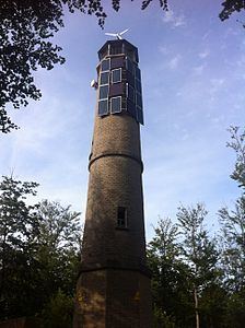
At 686.1 metres above sea level, the Brandeckkopf is the highest mountain of Offenburg. It is located within the Zell-Weierbach district. The Brandeckturm, an observation tower, stands at the summit. The mountain is said to have been given its name by the Celts, who brought burnt offerings here. The mountain lies within the 1897 hectare Brandeck landscape protection area.
References
Brandeckkopf Wikipedia(Text) CC BY-SA