
Cantons Zurich, Aargau Length 35 km Source Canton of Zürich | Source elevation 405 m | |
 | ||
River mouth Aare, Gebenstorf328 m (1,076 ft) Tributaries Left:Sihl, Schäflibach, Reppisch, Dorfbach SpreitenbachRight:Länggenbach, Furtbach, Lugibach, Gottesgraben Bridges Quaibrücke, Zürich, Münsterbrücke, Zürich, Hardbrücke, Rathausbrücke, Zürich, Bahnhofbrücke, Zürich Settlements | ||
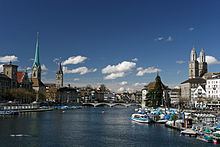
The Limmat is a river in Switzerland. The river commences at the outfall of Lake Zurich, in the southern part of the city of Zurich. From Zurich it flows in a northwesterly direction, after 35 km reaching the river Aare. The confluence is located north of the small town of Brugg and shortly after the mouth of the Reuss.
Contents
- Map of Limmat Switzerland
- The river limmat a great way to see zurich
- Power generationEdit
- NavigationEdit
- Towns near the riverEdit
- Cultural HeritageEdit
- References
Map of Limmat, Switzerland
The main towns along the Limmat Valley downstream of Zurich are Dietikon, Wettingen, and Baden. Its main tributaries are the Linth, via Lake Zurich, the Sihl, in Zurich, and the Reppisch, in Dietikon.
The hydronym is first attested in the 8th century, as Lindimacus. It is of Gaulish origin, from *lindo- "lake" and *magos "plain", and was thus presumably in origin the name of the plain formed by the Linth.
The river limmat a great way to see zurich
Power generationEdit
Like many Swiss rivers, the Limmat is intensively used for production of hydroelectric power: along its course of 35 km (22 mi), its fall is used by no less than ten hydroelectric power stations. These include:
NavigationEdit
Historically, the Limmat was an important navigation route. In the twelfth and thirteenth centuries, voyages from Zurich to Koblenz are recorded. In 1447, the Emperor Frederick III granted the privilege of free navigation on the Limmat and on the Rhine to Zurich. Because of the current, navigation was typically downstream only, with the barges being sold on arrival.
Today, the Limmat is navigable for much of its length by small craft only, with many of the hydroelectric power plants incorporating boat lifts. The traditional boat type used on the river is the weidling, a flat-bottomed vessel that is usually 10 metres (33 ft) long.
The uppermost stretch of the river through the centre of Zurich is navigable by rather larger vessels, albeit limited by low bridges. On this stretch of the river the Zürichsee-Schifffahrtsgesellschaft (Lake Zurich Navigation Company) operates its Limmat boat service, from the Landesmuseum to Lake Zurich, using low-profile motor boats.
Towns near the riverEdit
- Zurich
- Oberengstringen
- Unterengstringen
- Schlieren
- Dietikon
- Geroldswil
- Oetwil an der Limmat
- Spreitenbach
- Würenlos
- Neuenhof
- Wettingen
- Baden
- Ennetbaden
- Nussbaumen AG
- Untersiggenthal
- Turgi
Cultural HeritageEdit
Located on the then swamp land between Limmat and Zürichsee around Sechseläutzenplatz on small islands and peninsulas in Zürich, Prehistoric pile dwellings around Zürichsee were set on piles to protect against occasional flooding by the Linth and Jona. Zürich–Enge Alpenquai is located on Zürichsee lakeshore in Enge, a locality of the municipality of Zürich. It was neighbored by the settlements at Kleiner Hafner and Grosser Hafner on a then peninsula respectively island in the effluence of the Limmat, within an area of about 0.2 square kilometres (49.42 acres) in the city of Zürich. As well as being part of the 56 Swiss sites of the UNESCO World Heritage Site Prehistoric pile dwellings around the Alps, the settlement is also listed in the Swiss inventory of cultural property of national and regional significance as a Class object.