
Population 376 (in 2011) Civil parish Liddington Local time Friday 6:54 AM | OS grid reference SU207815 Dialling code 01793 | |
 | ||
Weather 2°C, Wind W at 11 km/h, 93% Humidity | ||
Liddington castle iron age hill fort swindon wiltshire uk
Liddington is a village and civil parish near Swindon in Wiltshire, England. The settlement lies southeast of Swindon town, close to junction 15 of the M4 motorway, which is approximately 2 miles (3.2 km) away via the B4192.
Contents
- Liddington castle iron age hill fort swindon wiltshire uk
- Map of Liddington Swindon UK
- Ben pgl activity instructor group leader at pgl liddington
- Starfish decoy control bunker
- References
Map of Liddington, Swindon, UK
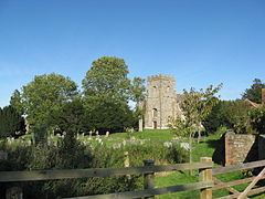
The parish has been an area of settlement since the earliest times. The ancient Ridgeway traverses the parish just north of the village and the Iron Age hill-fort known as Liddington Castle overlooks the present-day village. Liddington is recorded in the late Saxon period, around 940 AD. The Domesday Book of 1086 refers to the settlement as Ledentone. Records indicate that Liddington was a fairly prosperous parish in the 14th century. The population of the parish peaked at 454 in 1841 and then gradually declined.
Ben pgl activity instructor group leader at pgl liddington
'Starfish' decoy control bunker
Liddington Hill is the site of a control bunker for a World War II 'Starfish' bombing decoy site. This would have been used to control fires, which would have acted as a decoy to enemy planes targeting the town of Swindon to the north.
The bunker consisted of two rooms off a central passage. That on the right housed generators. The control room was on the left, with a hatch in its concrete roof.