
Built 1848 (1848) Opened 1848 Added to NRHP 27 June 2002 | NRHP Reference # 02000688 Area 6,900 m² | |
 | ||
Architectural styles Greek Revival architecture, Federal architecture | ||
Lenhart Farmhouse is a historic farmhouse located 1.5 miles south of the town of Monmouth on Piqua Road in Root Township, Adams County, Indiana. It was built about 1848, and was listed on the National Register of Historic Places in 2002.
Contents
- Federal I house
- Creek
- Native American trail that became Piqua Road
- Owners and property history
- References
The boundaries of the property include the historic Piqua Road, County Road 100E and the creek (Caffee Legal Drain) The 1.67-acre home site is located on a knoll overlooking an expansive field of rich river bottomland of the St. Marys River.
Federal "I" house
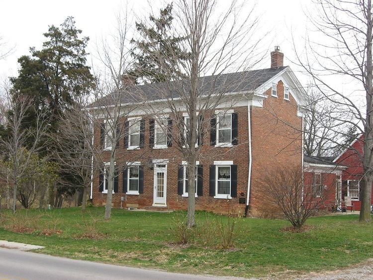
The primitive Federal I-house with Greek Revival details is a two-story masonry house with a gable roof and a rear masonry ell extension off of the west front room. On the east side of the ell was a 9-by-18-foot (2.7 by 5.5 m) porch. The porch was enclosed as a kitchen and a bedroom addition was built northeast side of the home between 1925 and 1931. Arnold Weidler who lived in the home during the construction provided this information to the author. The entire structure, both exterior and interior walls are of three brick thick common bond brick walls including a brick foundation and cellar. The structure prior to 1925 had only one timber-framed wall. That wall is the partition wall of the front foyer/stairwell, which divides the west front room from the foyer. In 1925 when the porch was enclosed the walls were framed with standard 2x4 wood studs 16 inches OC. The framed edition of 1925 was extended 8 feet in 1995 to meet the garage that was built on the property in 1993. The front elevation has 10 symmetrical openings on the first and second floors, five windows on the second story and two windows on each side of the front door. The lintels and sills are all limestone in the masonry structure. The replacement windows are six-over-six double hung units matching identically the original wood window intact in the east side of the masonry ell. This window in the east side of the masonry ell is one of six windows with rough-hewn wood lintels and sills. The other four are the attic windows. In addition are two small single pane cellar windows with two brick window wells. The three panel walnut front door has a three-pane transom ventilation window. The 7/12-pitched roof was originally shake shingles and is now finished in asphalt shingles with large flush end chimneys. The large wooden soffit has a massive decorative cornice that is consistent in size and presentation on the masonry walls as well as the wood framed walls on all elevations of the home. Common Bond is an arrangement of four to six stretcher courses between single header courses.
The west gable end of the "I" house and west side of the ell is one wall as indicated by the continuous brick pattern present from roof to foundation. This would indicate that the ell was integral part of the design and original construction. A cellar door is the only opening in the west gable end of the "I" house. The west portion of the ell has two openings a door and a window. The lintel and sill is limestone. The window is six-over-six double hung.
The north side of the home shows the masonry structure with a chimney and the framed porch enclosure and bedroom addition that was initiated in 1925 as well as the north gable side of the garage built in 1993. The large wooden soffit has a massive decorative cornice that is consistent in size and presentation on the masonry walls as well as the wood-framed walls on all elevations of the home. There are two windows that are vinyl-clad wood, with the sash being six-over-six double hung. The west side of the wood-framed bedroom addition from 1925 and garage from 1993 can be seen with 4-inch vinyl lap siding. One door opening exists in the north side of the framed area. An attic window opening is centered in the gable end of the north side of the garage.
The east view of the house shows the original masonry construction on the southeast portion of the structure as well as the framed bedroom addition initiated in 1925 and garage built in 1993 on the northeast portion with 4-inch vinyl lap siding. There are two openings in the home: a window opening and a door opening in the framed addition. The window is vinyl-clad wood with the sash being six-over-six double hung. The large wooden soffit has a massive decorative cornice that is consistent in size and presentation on the masonry walls as well as the wood-framed walls on all elevations of the home.
The interior of the Lenhart Farmhouse is a perfectly symmetrical Federal "I" House design with a central three-story walnut staircase and balustrade from the first floor to the attic. The east, west and ell room interior dimensions are 15 by 18 feet (4.6 by 5.5 m). Typical finishes include plaster and simple woodwork. Chair rails are found throughout the first floor "I" House rooms. The ash floorboards are of irregular widths from 4 to 8 inches wide. The walnut mopboards and quarter round are simply stated finishes to the plank floors. The interior doors on the first floor are three-panel walnut, and the exterior doors are two-panel poplar structurally designed with wooden pegs. All door jams and trim are poplar. The east fireplace is intact, with a large unadorned walnut mantle with only simple moldings. The west fireplace has been bricked and plastered over; none of the mantle remains. From evidence of the craftsmanship and plaster, it is conjecture by the author that the east fireplace was covered at the time of the c. 1925 enclosure of the porch. A stove access in the ell room has been bricked and plastered and a stove removed from that room in 1991.
The walnut staircase and balustrade starts in the front hall with a heavy turned newel post that goes through the ash plank flooring secured onto a heavy rough hewn beam in the cellar ceiling. The staircase has four landings: one at the second and attic floors and two located between floors. Windows are located on two of the four landings providing bountiful light and a stunning view north and south of the property. The railing is carved in sections gracefully turning at each landing and finally ending in the attic. The attic flooring is of milled 1-inch oak up 18 inches in width. The floor and ceiling joists are all of milled oak 2 inches × 8 inches and 2 inches × 4 inches, respectively.
The porch that was enclosed in c. 1925 is a 9-foot × 18-foot kitchen. The 20-by-22-foot (6.1 by 6.7 m) bedroom addition of c. 1925 was renovated c. 1955 as a rear hall and full bath. The bath has an authentic c. 1918 Victorian claw and ball tub installed in 1998. In 1998 an 8-foot extension connected the home with the garage and a utility room, coat closet and half bath were added. The custom doors in the addition are all four-panel with custom milled trim sympathetic to the "I" house woodwork and mopboards.
The second-floor bedrooms symmetrically located on the east and west sides of the "I" house are identical in size and proportion, 15 by 18 feet (4.6 by 5.5 m). They each have random-width plank floors. A dividing wall partition was added in 1991 providing symmetrical 5-foot × 15-foot closet area in each room and a full bath in the east room. The bath remodeled in 2012 with distressed cherry cabinetry and a claw tub. The two panel walnut doors, hardware and trim used for the closets were salvaged from a timber-framed home c. 1870 that was demolished on Winchester Road in Preble Township in Adams County in 1991.
The cellar floor was replaced in 1995. At that time it was determined that the brick walls were continuous foundation walls. A walnut cellar stair begin with a landing under the first-floor staircase near the kitchen and descends into the cellar. The last tread of the original cellar stair was removed due to water damage, and the remaining stringer was repaired with an oak stringer extension with oak risers and treads.
Creek
The creek was historically known as "Lenhart’s Run" as cited 1918 in the Adams County Commissioners records. The creek is a natural tributary of the St Marys River. The Native Americas called the river "Nameewa Siipiiwi" in the Myaamia language meaning, Sturgeon River. The proximity of the Lenhart Farm to the St. Marys River and Lenhart’s Run provided the rich agricultural soil. Historically this location was prized as "Bottomland of the first quality." The home sits on a knoll overlooking the watershed of the river. The dwelling site is located on what we now know as the 500-year flood plain. The creek is now known as "Caffee Legal Ditch."
Native American trail that became Piqua Road
Certainly one of the oldest roads in continuous use in Indiana, Piqua Road is thought to be a prehistory game trail around the "Great Black Swamp" of Northwest Ohio and Northeast Indiana. The trail is indicated on "Map of the Country about the Mississippi Drawn by Chegeree (Native American) who says he traveled through the country c. 1755. Size of the original hand drawn map is 16-1/4" x 13" and located at the Geography and Map Division of the Library of Congress in Washington DC. Other notable maps are Partie Occidentale de la Nouvelle France ou Canada 1755 and Neueste Karte Ohio 1845.
The Piqua Road follows the East Side of the St. Marys River for many miles. "It was an animal path. The animals instinctively followed the high ground and found the best route free of swamps and swales, sink holes and quicksand bottoms. Then, in time, it was used by the Indiana and when the white folks came there was a trail already made for them and the Piqua Road came into being." This route connected the Three River’s area of Fort Wayne, IN to an important area in Ohio called "Pickawillainy" that was a trading post or fort erected by traders in 1749.
A portion of Piqua Road was also known as the "Wayne Trace." This road was one of the routes of travel that supplied the troops garrisoned at Fort Wayne after General Anthony Wayne defeated the Myaamia (Miami) at the Battle of Fallen Timbers on August 20, 1794. The following year near Piqua, Ohio The Treaty of Greenville, regarded as one of the most important Native American treaties, was signed on August 3, 1795 between the United States and the Miami Confederacy.
In 1853 Samuel L. Rugg, simultaneously the Adams County Recorder and County Clerk and of Joseph D. Nuttman a prominent local businessman proposed building a 30-mile plank road through Adams County connecting Fort Wayne and Wilshire, OH. Therefore, the Fort Wayne and Piqua plank road was born. "There were certain specific specifications that must be adhered to. Some of which were that nothing but number one clear white oak plank should be used, without knot or knot holes, eight feet long, three inches thick and twelve inches in width, be laid side by side snugly and chummily. Stringers to be laid underneath and to be four by fours and of the same quality oak." This 16’ wide plank toll road served Adams County until about 1862. It had fallen into such disrepair that they discontinued collecting toll in 1866.
The origin of the name Piqua (pronounced Pe-quaw) comes from the "The Legend of Otath-he-wagh-Pe-Qua."
George C. Johnston, a trader for many years among the Indians and a member of the Shawnee tribe, explained the origin of the name Piqua. He was told by a member of the tribe, that many years ago the whole tribe was assembled at an annual feast and thanksgiving. They were all seated around a large fire, which having burned down to embers, a great puffing was observed in the ashes. Suddenly, a full-formed man sprang up from the remains of the fire and the tribe exclaimed in astonishment "Otaht-he-wagh-Pe-Qua." (He has come out of the ashes) And from that time, that place was called Piqua."
Owners and property history
A patent on this property was issued in 1836 from President Andrew Jackson of the United States Government to Benjamin Franklin Blossom of Van Wert County, Ohio. Benjamin Franklin Blossom was a young man of 16 years when he migrated West with his parents and siblings from Monmouth, Maine to east bank of the St. Marys River across from Wilshire, OH. in 1822. Fourteen years later at the age of 30, B.F. Blossom purchased the subject tract of land in Root Township in Adams County, IN. The Blossom family has a rich history in the European exploration and settlement of this country.
This family has a wonderful historic background, since the genealogy of this noble and patriotic family can be traced back to the Plymouth church at Leyden, Holland through the first known ancestor, Deacon Thomas Blossom (1580–1632) who was a leader of the above named church in Holland. The family is of purely English descent, having come from Plymouth, England at the time of the Pilgrim emigration to America. Thomas Blossom was on the Speedwell when she started out with the Mayflower in 1620. The Speedwell, however, sprang a leak and those on board were compelled to return to England. Later Thomas Blossom started again for America and landed on Plymouth Rock in 1629.
That the family has among their ancestors a lineal descendant from a Plymouth Pilgrim, Thomas Blossom, and a Captain of the Revolutionary War, James Blossom, is a highly prized distinction. They are connected with the early religious movements of this country and its educational history as well as the establishment of the American Independence and the preservation of the Republic during the days of the Civil War, the Spanish–American War and later the World Wars.
Captain James Blossom was a direct descendant in the fifth generation from Deacon Thomas Blossom and had a son by the name of Ansel Blossom. Ansel Blossom was born at Cape Cod, Kennebeck County, Maine, in 1778. While living in Maine Ansel taught school for a living. Ansel Blossom was married to Mercy Ladd in 1803. To this union were nine sons and two daughters. In 1822 he emigrated from Monmouth, Maine with his family to the West and entered and settled on a tract of land on the east bank of the St. Marys River across from Wilshire, OH. Ansel was a typical pioneer and faced the conditions, struggled with the difficulties, and endured the hardships of a new and undeveloped country. He filled his place in the rude society and served as the first Justice of the Peace in his new home bent his energies toward the improvement and raising of his family.
The third son of Ansel Blossom was Benjamin Franklin Blossom who was born in Maine in 1806 and died in Decatur, IN in 1875. In 1836 Benjamin Franklin Blossom at the age of 30 was issued the patent on the property in question which is located 1.5 miles from Monmouth, Indiana. There were subsequent sales and purchases by B. F. Blossom of several tracts of land in Root Township as documented in the Adams County Auditor's office. Clearly B. F. Blossom was instrumental in the settlement of Adams County Indiana which was founded in 1836 and it is conjecture of the officer that Benjamin Franklin Blossom named the oldest town in Adams County, Monmouth after Monmouth, Maine from whence his parents and siblings emigrated in 1822.
Monmouth, Indiana, is located in Root Township, Adams County Indiana and was laid out and the plat recorded on June 26, 1836. Benjamin Franklin Blossom served as the first elected School commissioner of Adams County in 1837 continuing in his father's vocation and service to learning and education. It was the school commissioner's responsibility to look after the common school revenues of the county and the examinations of the teachers as well as other duties. B. F. Blossom also served as Postmaster at Decatur from 1869 until his death in 1875.
On November 4, 1845, a warranty deed was recorded for the purchase of the tract of land in question from Benjamin Franklin Blossom to John Lenhard.
John and his wife Rebecca (Burl) moved their family to the property which was then it its wild state. They had ten children Lawson, John, Sarah, Peter, Catherine, Mary and Elizabeth (twins), Joseph, Ann and William. There were no improvements on the place and the family camped out two weeks beside a large oak log while a cabin was being built. It was made of round logs and scotched down on the inside, a puncheon floor, clapboard roof and a mud fireplace. They lived in this house a few years when John built the brick dwelling that is now standing on the site. John was born in Westmoreland County, Pennsylvania of February 24, 1797 and died May 18, 1877 in Decatur at the age of eighty years and three months. John spelled his name "Lenhard" even though perhaps it was mispronounced and in some publications misspelled leading to some confusion. Clearly Mr. Lenhard maintained this spelling in his adult life. This is illustrated when at the age of 68 he ran a lost and found advertisement in the Decatur Eagle newspaper published on Friday September 1, 1865. The advertisement read: "LOST. On Monday the 28th ult, between the residence of Dr. Trout and my own in Root township, a large old style calf skin pocket book, containing $55 in national currency, $5 of which was an Indiana bill, besides a small amount of postage currency. There were also a few papers but I am under the impression that none of them contained my name and residence. A reward of $5 will be paid for the return of the pocket book and contents. JOHN LENHARD."
John and his wife Rebecca attended Alpha church and were buried in the Alpha cemetery two miles north of their home at the southwest corner of the intersection of county roads 100E and 900N. The Alpha church was a log structure built in 1840 and was the first church in the township. All remnants of the church are long since gone but Ted Fuller, the former owner of the property south of the churchyard, remembers the cornerstones that served as the foundation stones of the log structure near the center of the property. The headstone of the Lenhards is intact but in the end John and Rebecca were laid to rest with the name spelled "Lenhart" as their children and grandchildren spelled the name. Their resting-place and headstone can still be seen in the northwest corner of the rural cemetery near a great oak tree.
John Lenhart took a full share of the responsibilities and hardships that went with pioneering. Mr. Lenhart was an elected County Commissioner for three years 1842, 1843 and 1844. He was an upstanding member of the agricultural community and was listed as a prominent citizen who was on the roster of the 1854 Agricultural Members. This organization supported an agricultural fair that was successful until the Civil War and then was discontinued. His work ethic and high standards remain a legacy to the community. His prodigy continued in civil and public service; Joseph his son a veteran of the Civil war, and John Henry Lenhart his grandson a prominent attorney. John H. was eulogized by the Adams County Bar association: "Whereas it has pleased the Supreme Judge of the Universe to remove from our midst our brother, companion, and fellow citizen, John H. Lenhart, it is resolved that in his death we have sustained a loss which we deeply deplore. As an officer of this court for eight years he was honest, upright and had ever in his mind the duties and responsibilities of his trust. As an attorney of this bar since the 7th day of October 1898 he was ever faithful and true to his clientage. Discharging the duties of his calling to the best of his knowledge and ability. As a citizen he was ever kind and courteous, leading a pure and open life, always ready to lend a helping hand to the needy and poor." E. Burt Lenhart the son of John H. Lenhart was also an attorney being a member of the firm Hooper & Lenhart and became one of the organizers of the Decatur Abstract & Loan Company. E. Burt Lenhart’s biography in the Standard History of Adams and Wells Counties Indiana written by Tyndall and Lesh in 1918 clarifies the history of his great great grandfather John Lenhard’s name evolved from Lenhard to Lenhart when his children and grandchildren changed the spelling of the name.
John Lenhart built a model farm in the rough and undeveloped territory of Root Township. The following is quoted from the Abstract of Title concerning the real estate description for the purpose of the Lenhart Executor’s sale. "The undersigned would further state that the above land constitutes what is known as the Lenhart farm, on the North bank of the St. Marys River about a mile from Decatur. The farm has upon it a good brick dwelling, a good orchard, a frame barn, corncribs and other outbuildings. It has never failing springs, also a sand and gravel back upon it; also a stone quarry, in the bed of the river. This farm is mostly bottomland of the first quality."
Nimrod Dailey and his wife Rosannah purchased the property for $11, 500.00 and a mortgage was recorded on October 11, 1880. Mr. Dailey had the property for only six years until his death on February 5, 1886. At that time in 1886 Rosannah maintained ownership of the property but she and her three children, Anna M., Jesse D. and Mary O. moved from their farm to the city of Decatur. The children continued to own the property subsequent their mother’s death in January 1919. The last heir of the family to own the property was Nimrod’s grandson Harry Daniel Dailey and his wife Louise. The Dailey family owned the property for 83 years but for only six years did Nimrod Dailey and his family farm the property. The additional 77 years that the farm remained in the family the land and house was occupied by tenants. Dailey family eventually sold the house but kept the tillable acreage.
A tenant of the home was Fred Weidler, who rented the home from 1925 to 1931. It was between 1925 and 1931 that Fred Weidler enclosed the back porch of the original structure to use as a kitchen and built an addition to the house to serve as a bedroom. These facts were given to the author orally by Arnold Weidler the son of Fred Weidler who presented several photographs of the property which include an excellent photographic history of the brick structure, the bedroom addition. On the photographs are Arnold Weidler and his twin brothers Paul and Wilfred.
On October 7, 1963, John and Letha Hutchison purchased the brick home with approximately 6 acres on the north side of Piqua Road and a warranty deed was recorded in Adams County IN. The ownership of the home and 6-acre site was transferred again when a warranty deed was recorded February 13, 1968, to Clois D. and Winona F. Eichar and a mortgage was recorded in the amount of $4441.18. Neither of these owners significantly changed the brick home. However, during the ownership of the Eichers the remaining outbuildings on the home site fell into disrepair and they demolished them. A building that was destroyed was a well-known milk house built near the spring on the north side of the home. The spring water was run into the milk house and the continuous stream of cool water chilled the milk.
On July 20, 1991, J. K. Sheets O’Beirne purchased at the Eicher estate sale 1.67 acres which included the brick home, orchard and spring from the original homesite. The home had been unoccupied for several years and was in a distressed condition. O’Beirne was responsible for the delicate, sympathetic restoration of the historic home as a functional residence. Significant changes to the property or structure since 1991 include: garage built in 1993, replaced concrete floor in the cellar 1995, kitchen, bath, utility area extended 8’ to the garage in 1998 and horse stable built in 2000.