
Length 479 km | ||
 | ||
States: Himachal Pradesh, Jammu and Kashmir Primarydestinations: LehSheyKaruUpshiGyaSarchu (state border)ZingzingbarPatseoDarchaJispaKeylongTandiSissuKhoksarGramphuRohtangManali Similar Rohtang Pass, Bara‑lacha la, Khardung La, Ladakh, Pangong Tso | ||
The Leh–Manali Highway (Hindi: लेह-मनाली राजमार्ग Lēh-manālī rājmārg) is a highway in northern India connecting Leh in Ladakh in Jammu and Kashmir state and Manali in Himachal Pradesh state. It is open for only about four and a half months in a year in summer between May or June, when the snow is cleared, and mid-October when snowfall again blocks the high passes. It connects Manali valley to Lahaul and Spiti valleys and Zanskar valley in Ladakh.
Contents
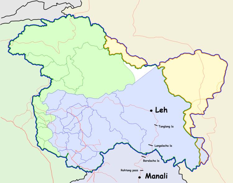
- Map of Leh Manali Hwy
- Geographical features
- Length of highway
- Route
- Distances
- Travel time
- Altitude sickness
- Climate along the highway
- Accommodation along the highway
- References
Map of Leh Manali Hwy
Leh–Manali Highway was designed and built and is maintained entirely by the Border Roads Organisation (BRO) of Indian army. It is capable of supporting the heaviest of army vehicles.
Geographical features
The average elevation of Leh-Manali highway is more than 4,000 m (13,000 feet) and its highest elevation is 5,328 m (17,480 ft) at Tanglang La mountain pass. It is flanked by mountain ranges on both sides featuring some stunning sand and rock natural formations.
The highway crosses many small streams of ice-cold water from snow-capped mountains and glacial melts without a bridge and it requires driving skill to negotiate fast-flowing streams. The landscape changes immediately after getting past Rohtang Pass and entering into Chandra river valley in Lahaul region that lies in rain-shadow. The greenery on the southern side of the mountain pass disappears and the mountain slopes on the leeward side become brown and arid. However, the mountain peaks are covered in snow and shine brightly in sun.
Leh-Manali highway is generally two lanes wide (one lane in either direction) without a road-divider but has only one or one and a half lanes at some stretches. It has over a dozen bailey bridges and most of them are in dilapidated condition. The highway has many damaged stretches and under-maintenance portions where even a little rainfall can trigger landslide making it very dangerous to cross that stretch of the road. The riding quality is not good at many places and fast speeds can cause discomfort.
Length of highway
The total length of the highway is about 490 km (300 mi). The distance in Himachal Pradesh state between Manali and Sarchu is 230 km (140 mi) and the distance in Ladakh region from Sarchu to Leh is 260 km (160 mi).
At Sarchu, Lahaul region ends at the Himachal Pradesh state border and Zanskar region starts in Ladakh region of Jammu and Kashmir state.
Route
Manali – Rohtang Jot - Gramphu - Kokhsar - Tandi - Keylong - Jispa - Darcha – Zingzingbar - Baralacha La - Bharatpur - Sarchu (state border) - Gata Loops - Nakee La - Lachulung La - Pang - More Plains - Tanglang La - Gya - Upshi - Karu - Leh
Distances
The distance from Lachalang La pass to the Tanglang La pass is 87 km (54 mi) via Pang.
Travel time
The Leh-Manali highway consists of generally bad stretches of roads, snow crossings, water crossings due to glacial melts and occasional landslides. It transverses high passes at over 5,000 metres. Travel time is unpredictable due to uncertainties of weather that can turn inclement any time and play spoilsport. The journey along the road normally takes at least two days if done in a rush, or more days depending on the condition of the road and vehicle (though minimum three days are advised for ordinary tourist because the real fun and pleasure is in the journey itself and not in reaching the destination). Tourists and travellers make overnight stops at Jispa and tented camps such as Sarchu. Alternately, overnight stops can be made at Keylong town.
The peak travel season is during May and June when a lot of tourists visit Rohtang pass. Most of the domestic tourists return to Manali and do not cross Rohtang pass towards north. Much of Rohtang pass remains covered by snow even during summer. Public buses start from Manali towards Keylong and onwards early at 4 am and after every two hours or so until 12 noon. The noon bus is the last one. The time taken until Keylong is 4 to 10 hours depending upon the condition of the road (that sometimes turns into a slush or becomes too slippery to travel because of fresh snowfall or melting of snow) and traffic jam that occurs at Beas nallah near Marhi and then at Rohtang pass. It is advisable to cross Rohtang pass before 8 am. Private four-wheel drive taxi are available. Share taxi are cheap as they charge per person but should be avoided by tourists as they are overcrowded with local residents and do not allow a good view of the outside. The fun in the journey is lost while travelling cramped in share taxi. Moreover, they cannot be stopped at will at any place. Some tourists travel from Manali to Leh and other places in Ladakh on motorcycles, generally in a group.
Altitude sickness
Owing to the rarefied atmosphere (low air pressure) at high altitude, less oxygen is breathed in and many travellers experience altitude sickness or acute mountain sickness. Before beginning the journey on the highway towards Leh, it is advisable to stay at the starting point Manali (altitude 1,950 m (6,400 ft)) one night and minimum one night at either Keylong, Jispa or Darcha to cope with the high passes and plains after Darcha. It is strongly advised not to sleep in Sarchu or Pang on the upward journey (towards Leh) as it can cause acute mountain sickness: headache, nausea, dizziness and vomiting. There have been deaths from AMS as well. The safe option is to camp at Leh or higher altitude after getting acclimated to lower oxygen levels. It is also advisable to carry chocolates, glucose or other high energy food on the journey and spend only a little time at the high mountain passes.
Climate along the highway
Ladakh is a cold semi-arid desert. It is cold along the highway even in summer (June onwards); the days are warm in bright sunshine but the nights are very cold. The water from glacial melts is ice-cold and one should avoid getting wet in water-crossings on the highway. Light woollens are required during the day and thick woollens at night. There is no rainfall between Rohtang pass and Leh even during the monsoon season in July–September as the entire region lies in rain-shadow. The greenery on the southern side of Rohtang disappears and the mountain slopes on the northern side become brown and arid. However, the mountain peaks are covered in snow and glare brightly in sun.
Accommodation along the highway
In India, a dhaba is a road-side eatery with low prices and no frills. It is not a motel. Such dhabas or eateries are found at some otherwise uninhabited places along the highway. Dhabas generally allow drivers to lie down and rest for a while. An occasional dhaba may provide a dormitory bed (without any associated facility) to a tourist at a low price.