
Elevation 2,753 m (9,032 ft) | Country Austria | |
 | ||
Mountains Rote Wand, Untere Wildgrubenspitze, Roggalspitze Similar | ||
The Lechquellen Mountains (German: Lechquellengebirge) or Lechquellen range is a small mountain group within the Northern Limestone Alps of the Eastern Alps. It lies entirely within the Austrian state of Vorarlberg and includes the upper reaches of the River Lech with its headstreams in a horseshoe shape as well as the Upper Großwalsertal valley.
Contents
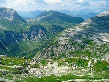
- Map of Lechquellen Mountains 6731 Austria
- Origin of the name
- Extent
- Neighbouring ranges
- Summits
- Alpine Club huts
- Long distance paths
- Klettersteigs
- References
Map of Lechquellen Mountains, 6731, Austria
Origin of the name
The name Lechquellengebirge (literally "Lech source mountains") is certainly accurate, for the greater part of the mountain range surrounds the upper reaches of the River Lech with its two spring-fed streams, the Formarinbach and the Spullerbach. Nevertheless, it is in fact an artificial name made up by Walther Flaig at a time when the development of mountaineering in the Alps had been largely completed. Previously, the mountain range had been called either the Klostertal Alps or counted as part of the Lechtal Alps east of the Flexen Pass.
Artificial names often find it hard to establish themselves in everyday language. By contrast, there are Alpine groups named after placenames that go back centuries or even millennia, such as the Raetikon or the neighbouring Verwall. Others are named after valleys that have been referred to by the same name from time immemorial, such as the Ötztal Alps. It will take decades to determine whether the name of the Lechquellen Mountains has prevailed as naturally as the name of other Alpine groups. It is also unclear whether the UIAA or even the European Union will work out and lay down an internationally recognized classification of the Alps. If they do, then the Lechquellen Mountains will either be officially recoginsed or absorbed into other groups.
Extent
The southern boundary of Lechquellen Mountains runs from the alpine town of Bludenz along the Klostertal to the Flexen Pass. From there, it continues in the east via Zürs and Lech and along the River Lech to its confluence with the Krumbach. The Krumbach forms the boundary of the range in the north up to the Hochtannberg Pass. From there, it runs along the Seebach via the village of Schröcken and continues along the Bregenzer Ach stream up to Au and its confluence with the Argenbach. Then it goes up the Argenbach until just before Damuels and continues along the Faschinabach in the west to the Faschinajoch saddle. From there it descends into the Große Walsertal and along the Lutz to its confluence with the Ill. It then follows the River Ill back to Bludenz.
The Flexen Pass connects the Lechquellen Mountains with the Lechtal Alps. The Hochtannberg Pass forms the link to the Allgäu Alps. The Faschinajoch is the connexion with the Bregenz Forest Mountains.
Walther Flaig, a well-known alpine guide and author from Vorarlberg, had a significant influence on the definition and extent of the Lechquellen Mountains. The name he gave to the mountains and his definition of their extent was included in the Alpine Club classification of the Eastern Alps (AVE).
Neighbouring ranges
The Lechquellen Mountains border on the following other groups in the Alps:
Summits
The 10 highest peaks in the Lechquellen Mountains are the:
Other well known peaks in the Lechquellen, in order of height are the:
Alpine Club huts
There are five Alpine Club huts in the mountains:
These huts, with the exception of the Frassen Hut, are part of the Lechquellenrunde.
Long-distance paths
North Alpine long-distance path 01, the Limestone Alps Way (Kalkalpenweg), crosses the Lechquellen as follows:
The Via Alpina, a cross-border long-distance path with five sections through the whole Alps, also runs through the Lechquellen Mountains.
The Red Trail of the Via Alpina (Rote Weg der Via Alpina) has 3 stages running through the Lechquellen as follows:
The Lechweg runs 125 km from lake Formarinsee to the Lechfall in Füssen (Germany).