
Elevation 2,994 ft (913 m) Easiest route drive up and hike | First ascent unknown | |
 | ||
Topo map USGS Ohiopyle, Mill Run, Kingwood, Seven Springs, Bakersville, Ligonier, Boswell, Rachelwood, Vintondale, Johnstown, New Florence (PA) Quadrangle Similar Laurel Hill Tunnel, Laurel Mountain State Park, Kooser State Park, Laurel Summit State Park, Allegheny Mountains | ||
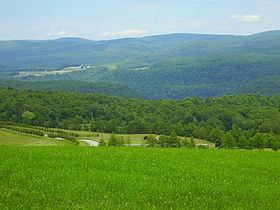
Laurel Hill, also known as Laurel Ridge or Laurel Mountain, is a 70-mile-long (110 km) mountain in Pennsylvania's Allegheny Mountains. This ridge is flanked by Negro Mountain to its east and Chestnut Ridge to its west. The mountain is home to six state parks: Laurel Ridge State Park, Laurel Mountain State Park, Linn Run State Park, Kooser State Park, Laurel Hill State Park, and Ohiopyle State Park. The 70-mile-long (110 km) Laurel Highlands Hiking Trail runs the length of the ridge.
Contents
- Map of Laurel Hill Ligonier Township PA 15531 USA
- GeologyEdit
- ClimateEdit
- Flora and faunaEdit
- References
Map of Laurel Hill, Ligonier Township, PA 15531, USA
Two state forests, comprising over 22,000 acres (89 km2), are located on Laurel Hill: Gallitzin State Forest and Forbes State Forest. State Game Lands 42 and 111 are also located on the mountain and also comprise a little over 22,000 acres (89 km2).
Laurel Hill has an average elevation of 2,700 ft (820 m) along its length, while there are individual "knobs" that rise above 2,900 ft (880 m). The highest point is above the Seven Springs Mountain Resort at 2,994 ft (913 m). Laurel Hill is flanked on its north end by the Conemaugh Gorge and on its south end by the Youghiogheny Gorge, both water gaps being approximately 1,700 ft (520 m) in depth. The ridge continues north of the Conemaugh Gorge for several miles as Rager Mountain, which reaches an elevation of 2,580 feet (790 m). South of the Youghiogheny Gorge, a short ridge, generally still labeled Laurel Hill, at the edge of Ohiopyle State Park, reaches above 2,920 feet (890 m).
The city of Johnstown and borough of Ligonier are located near its northern end, while the boroughs of Confluence and Ohiopyle are located towards its southern end. Two major highways cross Laurel Hill, the Pennsylvania Turnpike and U.S. Route 30. The abandoned Laurel Hill Tunnel goes beneath Laurel Hill. A number of smaller state roads cross at other points on the mountain.
GeologyEdit
Laurel Hill is made up of Mississippian and Pennsylvanian clastic sedimentary rocks, consisting mostly of conglomerate, sandstone, and shale. Formations include the Burgoon, Mauch Chunk, Pottsville, and Allegheny. The mountain is anticlinal in structure.
Along the length of this ridge there are several prominent knobs that rise from the ridgeline. They are as follows south to north: Sugarloaf Knob 2,667 ft (813 m), Highpoint 2,994 ft (913 m), Birch Rock Hill 2,934 ft (894 m), Painter Rock Hill 2,920 ft (890 m), Bald Knob 2,930 ft (890 m), Ulery Hill 2,820 ft (860 m), Pea Vine Hill 2,900 ft (880 m), Pikes Peak 2,840 ft (870 m), Mystery Hill 2,880 ft (880 m), and Sugar Camp Hill 2,908 ft (886 m).
ClimateEdit
The Laurel Hill region shares the humid continental climate of the Middle Atlantic Region of the United States. The mountain ridge, however, has an influence on the local weather patterns, and can cause air temperatures to be several degrees cooler than the surrounding towns and valleys. A difference of 5 to 10 °F (−15 to −12 °C) cooler can be noted depending on weather variables. The orography along with moisture from the Great Lakes can cause heavy snowfall during winter months.
The mountain ridge is oriented at right angles to approaching weather systems, forcing the prevailing westerly airflows upward. As rising air cools, moisture in the air mass condenses, once reaching the saturation point, precipitation results. Laurel Hill may also act as a barrier to systems and slow the movement of storms having an impact on the local area, forming a "micro-climate". Although this mountain is not high enough to create its own weather, its structure is enough to gently nudge weather from hot to warm, cool to cold and from rain to snow.
Flora and faunaEdit
Laurel Hill has a diversity of habitats, and with that comes a variety of birds and mammals. The raven and wild turkey are frequently seen on this mountain. The hermit thrush, Canada warbler, brown creeper, and winter wren all nest near the bog at Spruce Flats. During the summer, black-throated and blue warblers, solitary and red-eyed vireos are seen. Raptors on the mountain include the broad winged, red tailed and red shouldered hawks, along with barred owls.
Commonly seen mammals on the mountain include; white-tailed deer, chipmunks, red and gray squirrels. More elusive animals include the woodchuck, raccoon, and opossum. Black bear have also been seen on this mountain but are shy and reclusive and not likely to be come across.
Snakes also make their home on Laurel Hill including the timber rattler and copperhead snakes. Caution should be exercised during the summer months when hiking around rocks and scree areas.