
Topo map USGS Ohiopyle, PA Prominence 70 m | Elevation 810 m Mountain range Allegheny Mountains | |
 | ||
Similar Mount Davis, Spruce Knob, Sugarloaf Mountain | ||
Sugarloaf knob
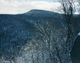
Sugarloaf Knob is a well-known summit within Ohiopyle State Park on the south end of the Laurel Ridge. This mountain has a unique profile and can easily be recognized at different lookouts in the park and surrounding area. The Youghiogheny River cuts beneath the "knob" and Laurel Hill creating a 1,700-foot (520 m) deep chasm. The highest peak in the area is the south end of the Laurel Hill Ridge as it reaches 2,920 ft (890 m) above sea level.
Contents
- Sugarloaf knob
- Map of Sugarloaf Knob Stewart Township PA 15459 USA
- Red sled on sugarloaf knob
- References
Map of Sugarloaf Knob, Stewart Township, PA 15459, USA
Sugarloaf Knob is easily accessible by a park road which takes you to just below the summit. A short bushwhack from there will get you to the top of the mountain.
Red sled on sugarloaf knob
References
Sugarloaf Knob Wikipedia(Text) CC BY-SA