
Primary inflows Basin countries United States Surface elevation 328 m | Primary outflows Carp River Surface area 133 acres (0.5 km) Area 54 ha Outflow location Carp River | |
 | ||
Similar Porcupine Mountains, Bond Falls, Manabezho Falls, Lake of the Clouds Overlook, Manido Falls | ||
Lake of the clouds upgraphics com
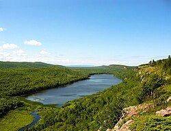
Lake of the Clouds is a lake located in Ontonagon County in the Upper Peninsula of the U.S. state of Michigan within the Porcupine Mountains Wilderness State Park. The lake is situated in a valley between two ridges in the Porcupine Mountains. Surrounded by virgin wilderness and stunning vistas, the lake is a popular destination for hikers, campers, and fishermen.
Contents
- Lake of the clouds upgraphics com
- Map of Lake of the Clouds Carp Lake Township MI 49953 USA
- Lake of the clouds porcupine mountains
- References
Map of Lake of the Clouds, Carp Lake Township, MI 49953, USA
The lake is a prominent feature of the park, and can be viewed at the Lake of the Clouds Overlook at the west terminus of former Michigan highway M-107. The state park occasionally hosts a nighttime sky watch at the lake. The lake is fed from the east end by the Carp River Inlet and the outflow from the western end is the Carp River, which empties into Lake Superior on the boundary between Ontonagon and Gogebic County.