
Basin countries France Surface elevation 477 m | Primary inflows Catchment area 1,591 km (614 sq mi) Surface area 22 km (8.5 sq mi) Area 22 km² Outflow location Verdon | |
 | ||
Similar Verdon Gorge, Alps, Lac de Castillon, Lac de Serre‑Ponçon, Calanque | ||
Moving clouds lake of sainte croix
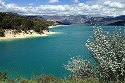
The Lake of Sainte-Croix (French: lac de Sainte-Croix) is a man-made lake that was formed by the construction, between 1971 and 1974 (when it was put into service) of a reinforced-concrete arch dam by the name of Dam of Sainte-Croix. The reservoir holds a maximum of 761 million cubic metres of water. The dam, which generates 142 million kWh of electricity per year, is 94 metres high, 7.5 metres thick at its base and 3 metres thick at its crest.
Contents
Map of Lake of Sainte-Croix, France
The village that can be seen adjacent to the lake, however, is not the eponymous village of Sainte-Croix-de-Verdon but Les Salles-sur-Verdon. The original village is now completely underwater.
The other villages around the lake are:
References
Lake of Sainte-Croix Wikipedia(Text) CC BY-SA