
Type reservoir Max. depth 69.8 ft (21.3 m) | Primary inflows Area 228.5 km² Inflow source Mississippi River | |
 | ||
Surface area 56,471.4 acres (22,853.2 ha) | ||
In depth outdoors on ice 0026 tips for tullibee on lake winnibigoshish big winnie
Lake Winnibigoshish is a body of water in north central Minnesota, in the Chippewa National Forest. Its name comes from the Ojibwe language Wiinibiigoonzhish, a diminutive and pejorative form of Wiinibiig, meaning "filthy water" (i.e. "brackish water"). The name is related in structure to Lake Winnipeg and to the Algonquian name for Green Bay, which the Ho-chunk (Winnebago) Nation was named after.
Contents
- In depth outdoors on ice 0026 tips for tullibee on lake winnibigoshish big winnie
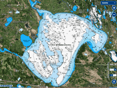
- Map of Lake Winnibigoshish Minnesota USA
- References
Map of Lake Winnibigoshish, Minnesota, USA
The former Winnibigoshish Township (now unorganized), located on the north shore of Lake Winnibigoshish, in Itasca County, Minnesota, was named after this lake.
References
Lake Winnibigoshish Wikipedia(Text) CC BY-SA